The natural and social history of the indigenous lands and ...in development policy and planning,...
13
, 20120164, published 22 April 2013 368 2013 Phil. Trans. R. Soc. B Junqueira and Maurício Torres Barbara Zimmerman, Paulo Junqueira, Adriano Jerozolimski, Marcelo Salazar, Rodrigo Prates Stephan Schwartzman, André Villas Boas, Katia Yukari Ono, Marisa Gesteira Fonseca, Juan Doblas, protected areas corridor of the Xingu River basin The natural and social history of the indigenous lands and Supplementary data ml http://rstb.royalsocietypublishing.org/content/suppl/2013/04/17/rstb.2012.0164.DC1.ht "Data Supplement" References http://rstb.royalsocietypublishing.org/content/368/1619/20120164.full.html#related-urls Article cited in: http://rstb.royalsocietypublishing.org/content/368/1619/20120164.full.html#ref-list-1 This article cites 25 articles, 6 of which can be accessed free Subject collections (207 articles) environmental science Articles on similar topics can be found in the following collections Email alerting service here right-hand corner of the article or click Receive free email alerts when new articles cite this article - sign up in the box at the top http://rstb.royalsocietypublishing.org/subscriptions go to: Phil. Trans. R. Soc. B To subscribe to on April 22, 2013 rstb.royalsocietypublishing.org Downloaded from
Transcript of The natural and social history of the indigenous lands and ...in development policy and planning,...
, 20120164, published 22 April 2013368 2013 Phil. Trans. R. Soc. B Junqueira and Maurício TorresBarbara Zimmerman, Paulo Junqueira, Adriano Jerozolimski, Marcelo Salazar, Rodrigo Prates Stephan Schwartzman, André Villas Boas, Katia Yukari Ono, Marisa Gesteira Fonseca, Juan Doblas, protected areas corridor of the Xingu River basinThe natural and social history of the indigenous lands and
Supplementary data
ml http://rstb.royalsocietypublishing.org/content/suppl/2013/04/17/rstb.2012.0164.DC1.ht
"Data Supplement"
References
http://rstb.royalsocietypublishing.org/content/368/1619/20120164.full.html#related-urls Article cited in:
http://rstb.royalsocietypublishing.org/content/368/1619/20120164.full.html#ref-list-1
This article cites 25 articles, 6 of which can be accessed free
Subject collections (207 articles)environmental science �
Articles on similar topics can be found in the following collections
Email alerting service hereright-hand corner of the article or click Receive free email alerts when new articles cite this article - sign up in the box at the top
http://rstb.royalsocietypublishing.org/subscriptions go to: Phil. Trans. R. Soc. BTo subscribe to
on April 22, 2013rstb.royalsocietypublishing.orgDownloaded from
on April 22, 2013rstb.royalsocietypublishing.orgDownloaded from
rstb.royalsocietypublishing.org
ReviewCite this article: Schwartzman S et al. 2013
The natural and social history of the indigen-
ous lands and protected areas corridor of the
Xingu River basin. Phil Trans R Soc B 368:
20120164.
http://dx.doi.org/10.1098/rstb.2012.0164
One contribution of 18 to a Theme Issue
‘Ecology, economy and management of an
agroindustrial frontier landscape in the
southeast Amazon’.
Subject Areas:environmental science
Keywords:Amazon, indigenous lands, protected areas,
Xingu
Author for correspondence:Stephan Schwartzman
e-mail: [email protected]
& 2013 The Author(s) Published by the Royal Society. All rights reserved.
Electronic supplementary material is available
at http://dx.doi.org/10.1098/rstb.2012.0164 or
via http://rstb.royalsocietypublishing.org.
The natural and social history of theindigenous lands and protected areascorridor of the Xingu River basin
Stephan Schwartzman1, Andre Villas Boas2, Katia Yukari Ono2, MarisaGesteira Fonseca2, Juan Doblas2, Barbara Zimmerman1, Paulo Junqueira2,Adriano Jerozolimski3, Marcelo Salazar2, Rodrigo Prates Junqueira2
and Maurıcio Torres2
1Environmental Defense Fund, 1875 Connecticut Avenue, NW, Washington, DC 20009, USA2Instituto Socioambiental, Av. Higienopolis, 901, Higienopolis, Sao Paulo 01238-001, Brazil3Associacao Floresta Protegida, Rua do Mogno, 240, Tucuma, PA 68385-000, Brazil
The 280 000 km2 Xingu indigenous lands and protected areas (ILPAs) corri-
dor, inhabited by 24 indigenous peoples and about 215 riverine (ribeirinho)
families, lies across active agriculture frontiers in some of the histori-
cally highest-deforestation regions of the Amazon. Much of the Xingu is
anthropogenic landscape, densely inhabited and managed by indigenous
populations over the past millennium. Indigenous and riverine peoples’
historical management and use of these landscapes have enabled their
long-term occupation and ultimately their protection. The corridor vividly
demonstrates how ILPAs halt deforestation and why they may account for
a large part of the 70 per cent reduction in Amazon deforestation below
the 1996–2005 average since 2005. However, ongoing and planned dams,
road paving, logging and mining, together with increasing demand for agri-
cultural commodities, continued degradation of upper headwaters outside
ILPA borders and climate change impacts may render these gains ephem-
eral. Local peoples will need new, bottom-up, forms of governance to gain
recognition for the high social and biological diversity of these territories
in development policy and planning, and finance commensurate with the
value of their ecosystem services. Indigenous groups’ reports of changing
fire and rainfall regimes may themselves evidence climate change impacts,
a new and serious threat.
1. Introduction: indigenous lands, protected areas and Amazondeforestation
The 280 000 km2 of indigenous lands and protected areas (ILPAs) of the Xingu
River basin form a continuous forest corridor larger than the UK, inhabited by
25 indigenous peoples and about 215 riverine (ribeirinho) families. Directly adja-
cent to the arc of deforestation in Para and Mato Grosso, the Xingu ILPAs are a
clear example of how Brazilian government policy has worked to reduce
Amazon deforestation rates over 70 per cent below the historic average since
2005 (http://www.obt.inpe.br/prodes/index.php accessed 21 February 2013)
([1]; figure 1). However, ongoing and planned infrastructure works (the Belo
Monte dam, possible upstream dams on the Xingu, paving of the 163 highway),
current and projected logging and mining, and emerging climate change
impacts [5] suggest that these gains may prove ephemeral unless ILPAs and
their socio-environmental value are recognized and incorporated into develop-
ment strategies. In this study, we examine the history of the Xingu ILPAs in the
context of modern Brazilian indigenous policy, contrasted to other tropical
forest regions. We explore the conditions that enable and threaten the corridor’s
continued effectiveness against deforestation, and identify strategies to protect
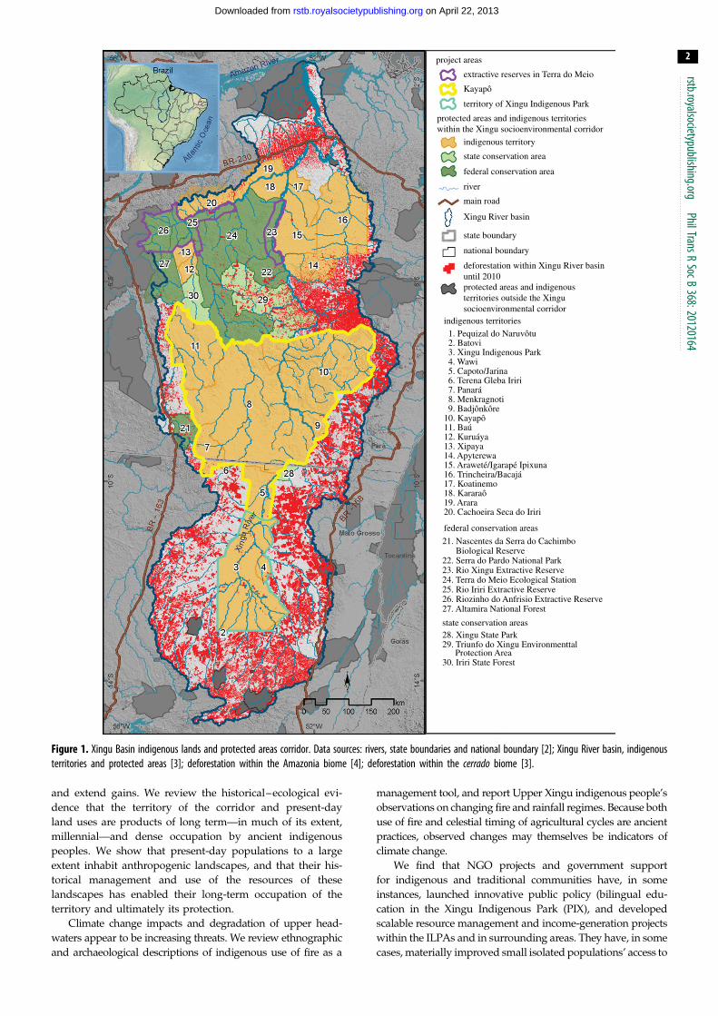
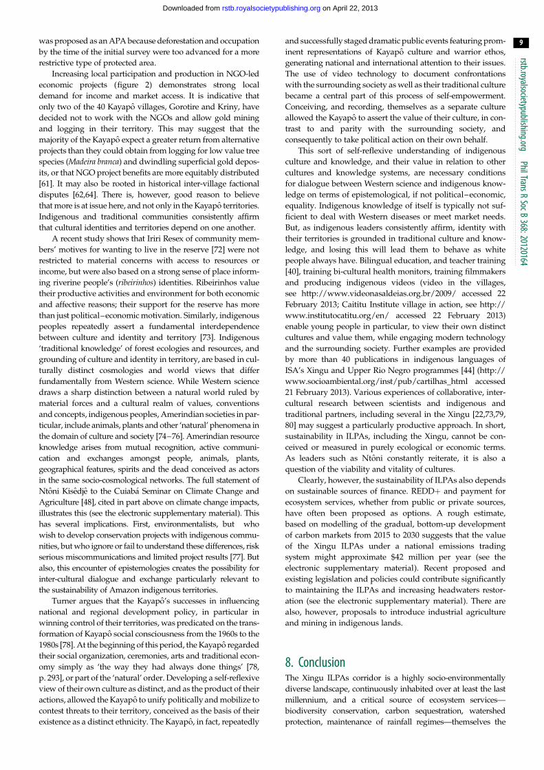
project areas
extractive reserves in Terra do Meio
Kayapô
territory of Xingu Indigenous Park
indigenous territory
state conservation area
federal conservation area
river
main road
Xingu River basin
state boundary
national boundary
indigenous territories
1. Pequizal do Naruvôtu2. Batovi3. Xingu Indigenous Park4. Wawi5. Capoto/Jarina6. Terena Gleba Iriri7. Panará8. Menkragnoti9. Badjônkôre
10. Kayapô11. Baú12. Kuruáya13. Xipaya14. Apyterewa15. Araweté/Igarapé Ipixuna16. Trincheira/Bacajá17. Koatinemo18. Kararaô19. Arara20. Cachoeira Seca do Iriri
federal conservation areas
21. Nascentes da Serra do Cachimbo Biological Reserve22. Serra do Pardo National Park23. Rio Xingu Extractive Reserve24. Terra do Meio Ecological Station25. Rio Iriri Extractive Reserve26. Riozinho do Anfrisio Extractive Reserve27. Altamira National Forest
state conservation areas28. Xingu State Park29. Triunfo do Xingu Environmenttal
Protection Area30. Iriri State Forest
deforestation within Xingu River basinuntil 2010protected areas and indigenousterritories outside the Xingusocioenvironmental corridor
protected areas and indigenous territorieswithin the Xingu socioenvironmental corridor
Figure 1. Xingu Basin indigenous lands and protected areas corridor. Data sources: rivers, state boundaries and national boundary [2]; Xingu River basin, indigenousterritories and protected areas [3]; deforestation within the Amazonia biome [4]; deforestation within the cerrado biome [3].
rstb.royalsocietypublishing.orgPhilTransR
SocB368:20120164
2
on April 22, 2013rstb.royalsocietypublishing.orgDownloaded from
and extend gains. We review the historical–ecological evi-
dence that the territory of the corridor and present-day
land uses are products of long term—in much of its extent,
millennial—and dense occupation by ancient indigenous
peoples. We show that present-day populations to a large
extent inhabit anthropogenic landscapes, and that their his-
torical management and use of the resources of these
landscapes has enabled their long-term occupation of the
territory and ultimately its protection.
Climate change impacts and degradation of upper head-
waters appear to be increasing threats. We review ethnographic
and archaeological descriptions of indigenous use of fire as a
management tool, and report Upper Xingu indigenous people’s
observations on changing fire and rainfall regimes. Because both
use of fire and celestial timing of agricultural cycles are ancient
practices, observed changes may themselves be indicators of
climate change.
We find that NGO projects and government support
for indigenous and traditional communities have, in some
instances, launched innovative public policy (bilingual edu-
cation in the Xingu Indigenous Park (PIX), and developed
scalable resource management and income-generation projects
within the ILPAs and in surrounding areas. They have, in some
cases, materially improved small isolated populations’ access to

rstb.royalsocietypublishing.orgPhilTransR
SocB368:201
3
on April 22, 2013rstb.royalsocietypublishing.orgDownloaded from
healthcare, education and markets. NGOs have enabled local
communities to organize their own institutions—critical to
building capacity to manage their territories. However, larger-
scale sustainable sources of finance will be needed to address
current threats. Payment for ecosystem services, including
reducing emissions from deforestation and forest degradation
(REDDþ), potentially including both public and private
sources, could attain the scale needed.
Indigenous and traditional leaders call for better access to
healthcare, education and markets—but also emphasize that
territorial integrity from their perspective, depends on cul-
tural identity and vice versa. Bilingual education, bicultural
teacher and healthcare provider training, publications in indi-
genous languages, and mentoring indigenous filmmakers
and inter-cultural researchers support indigenous peoples’
self-reflexive examination and valuation of their own cultures
as cultures that contrast to but are in parity with others. Criti-
cal perspectives on cultural difference may be an important
condition for the sustainability of these territories.
201642. Indigenous peoples: pre-colonial majorities topost-colonial minorities
Worldwide, much of the remaining tropical forest is also indi-
genous territory (i.e. occupied by social, cultural, linguistic and
religious minorities, pre-dating European colonization and
national governments) [6,7]. But this observation is only pos-
sible from a post-second world war, post-colonial vantage,
through the lens of third- and fourth-world mobilizations
and recent international law and accords [8,9]. ‘Indigenous-
ness’ is, in the first instance, a relationship between colonizer
and colonized. Indigenous policies in different regions were
conditioned by differing strategies of colonial administration.
In nineteenth century Africa and Indonesia, colonial defi-
nitions of the ‘native’ as a political identity became the
conceptual basis for indirect rule [10,11]. Identification of
specific ethnic groups with fixed geographies and the attribu-
tion of a unique customary law and administrative ‘native
authority’ to each tribe effectively divided colonized
majorities into numerous, competing native minorities, in
Africa in particular leading to intractable inter-ethnic con-
flicts. Colonial identification of specific ethnicities with
fixed geographies produced a legacy of severe inter-ethnic
tensions and conflict in Africa, and coloured regional and
ethnic autonomy movements in colonial and post-colonial
Indonesia. Identifying ethnicities with geographies in the
Amazon in the twentieth century was a very different matter.
Modern Brazilian indigenous policy starting in the
1940s, based on existing evidence of demographic trends
and prevailing ethnological theory, assumed that the story
of the surviving descendants of pre-Columbian populations
was winding to a close. Based on available census data and
evidence of dwindling populations and indigenous assimila-
tion, policy-makers and anthropologists alike concluded that
indigenous peoples were a small minority destined, if not to
altogether disappear, lose any vestiges of specific cultural
identity [12,13]. Indigenous populations in the Amazon in
the mid-twentieth century were probably approaching a
historical nadir [14].
What were taken for the demographic facts on the ground
at the end of the 1960s had a crucial influence on indigenous
policy. Military government founders of the National Indian
Foundation (FUNAI) believed that they were dealing with a
very small and diminishing population that could easily be
accommodated on limited lands a until such time as they
became integrated into the national society. However, indigen-
ous groups and anthropologists found that the land rights
guaranteed in the 1973 Indian Statute applied to many more
peoples than its framers anticipated. Fifteen years of public
conflicts ensued between military leaders of FUNAI and
anthropologists, indigenous rights activists and indigenous
groups over who could be considered Indian [15–17]. The
1988 Constitution recognized the right of indigenous groups
to maintain traditional cultures permanently, making indigen-
ous land and resource rights permanent [18,19] and becoming
the basis for large-scale demarcation of indigenous territories.
In numerous local struggles and in the forum of national law
and policy, indigenous peoples successfully gained recognition
of their rights to specific geographies—and hence for control
over 20 per cent of the Amazon. The indigenous population,
while small (approx. 0.4% of the national total), is growing,
and indigenous ethnicities, rather than disappearing, are
proliferating [20].
3. Historical ecology and indigenous resourcemanagement: ancient populations andpresent-day resources
(a) Historical ecologyThe Xingu River rises in the woodlands–savannah and transi-
tional, semi-deciduous forest of northern Mato Grosso and
flows north through the dense, moist forest of Para for
2700 km to empty into the Amazon. A clear water river, it
drains a landscape of ancient crystalline pre-Cambrian shield.
The Xingu basin covers 51 million ha, of which approximately
20 million ha is officially recognized indigenous land, whereas
another 8 million ha is protected areas [3].
Much of the Xingu was, and continues to be, an anthropo-
genic landscape [21], continuously occupied, managed and
modified over at least the past 1200–1500 years. Many of
the resources indigenous and riverine communities use are
indicators or products of this earlier occupation (e.g. Brazil
nuts, babassu palm, dark earths and vine forests). This
includes, at least, the Upper Xingu, Kayapo and Panara terri-
tories, Assurini and Arawete indigenous lands, the Anfrızio,
Xingu and Iriri rivers from the north to the south of the Terra
do Meio [22–25].
Large parts of the middle Xingu (Arawete, Assurini,
Kayapo and Panara indigenous lands, Anfrısio, Iriri and
Xingu Extractive Reserves) are characterized by abundant
deposits of Amazon dark earths (ADEs), archaeological
remains and disturbance indicators including heavily used
species such as Brazil nuts (Bertholletia excelsa), babassu
palm (Orbignya phalerata) and liana forests [21,25]. Some 215
riverine families along several hundred kilometres of the
middle Xingu, Iriri and Anfrizio rivers almost without excep-
tion inhabit and plant in dark earths, and regularly encounter
potsherds, stone axes, ceramics and figurines. This is also the
case for all the Kayapo communities in Para [25,26]. Contem-
porary land use and resource management in the Xingu
corridor is thus significantly conditioned or made possible
by mostly little-studied prehistoric land-use practices.
rstb.royalsocietypublishing.orgPhilTransR
SocB368:20120164
4
on April 22, 2013rstb.royalsocietypublishing.orgDownloaded from
Archaeological sites evidence ancient pre-Columbian occu-
pation throughout the Xingu basin, although only the Upper
Xingu has been the object of sustained archaeological research
[22,23]. Occupation of the Xingu headwaters dates to about AD
800–900. Based on remains from the middle Xingu, similar
to archaeological material dated to AD 1000 and AD 1580 on
the Tocantins, Balee [21] suggests that two major indigenous
societies occupied these regions in prehistoric times. Archaeol-
ogy of the Xingu documents much larger populations than
those registered by modern ethnology, as well as complex
settlement patterns and large-scale transformation and
management of forest cover and other landscape features
[22,23]. In the Upper Xingu, in particular, large settlements
surrounded by earthworks and palisades connected by exten-
sive road networks from about AD 1250–1600 show marked
cultural continuities with contemporary societies (ceramics,
settlement location and patterns, and land use).
There are indications of sporadic incursions—with prob-
ably devastating demographic consequences—of Portuguese
slavers and prospectors in the Upper Xingu in the mid-eight-
eenth century [27]. Kayapo and Yudja, fleeing colonists, gold
miners, rubber tappers and missionaries occupied the still rela-
tively isolated middle Xingu in the first half of the nineteenth
century. Intensive occupation of the basin began only in the
1970s, with the opening of the Transamazon, BR 163 and BR
158 highways through the basin and the arrival of colonists
from southern Brazil. The Xingu headwaters region has
become one of the major cattle- and soya bean-producing
regions in Mato Grosso, whereas the county of Sao Felix do
Xingu in Para has the largest cattle herd in Brazil of over two
million head. There are currently some 610 000 people living
in 35 counties in the basin [3].
(b) Fire and indigenous resource managementEthnographic and archaeological data from the Xingu and
other regions of the Amazon and the Americas suggest that
fire was an important landscape and resource management
tool dating to prehistoric times. This is significant in the light
of Upper Xingu peoples’ current observations on changes in
fire regimes (see 4a(ii)). If fire has been used to manage land-
scapes for centuries—if not millennia—and only now is
perceived as a threat in the region of the basin most vulnerable
to climate change impacts, then these observations themselves
may be taken as indicators of climate change.
The use of fire as a management tool in the pre-Columbian
Americas is widely reported and evidenced in charcoal found
in soil and lake sediment deposits that declines post-1500
[28–31]. Indeed, several authors propose that post-pandemic
emissions reductions and carbon sequestration, as forest regen-
erated on previously fire-cleared and managed indigenous
farmland, contributed significantly to the Little Ice Age of the
sixteenth–eighteenth centuries [32,33]. Use of fire in swidden
agriculture is ubiquitous in the Amazon [34, p. 191]. Repeated
burning of plant materials is central to forming ADEs [35], such
that ADE deposits evidence long-term use of fire as a manage-
ment tool. Beyond this, Heckenberger reports that present-day
Upper Xingu groups regularly burn floodplain savannah and
scrub forest from June to September. Many tree and ground-
cover species appear to be fire-resistant and quickly regenerate.
Burning stimulates dense regrowth of sape grass (Imperataspp.), used for housing thatch, and also renders clay soils fri-
able and more easily worked (M. Heckenberger, personal
communication, 11 October 2012). Hecht argues that ethno-
graphic observations of the use of fire and other management
techniques among the Kayapo of the Xingu basin may shed
light on the historical formation of ADEs. ‘Burning is a low-
level, relatively constant activity used to maintain cerrado for-
mations; to favour certain vegetation in some areas, such as
the inaja (Attalea sp.) and tucuma (Astrocarym sp.) palm
groves which are important for attracting herds of pigs and
for building materials; to clear for agriculture; for weeding;
possibly to control plant pathogens and insects.’ [36,
pp. 363–364]. These observations of Kayapo are consistent
with my observations of the Panara [37]. The Panara in the
early 1980s, burned cleared forest for swiddens, regularly re-
burned weeds and crop residue in gardens, and burned
around the village and on paths to keep them clear. When on
hunting, fishing or collecting expeditions in the forest they
never put out cooking fires or fires set to collect honey, and
even at the height of the dry season, these fires extinguished
themselves. There is ample archaeological, historical and eth-
nographic evidence that indigenous groups routinely used
fire as a management tool in a variety of ecological contexts
over a very long period of time. It will be important to under-
stand current Upper Xingu peoples’ observations on fire
regimes in the light of the evidence for the prevalence of fire
in indigenous landscape and resource management.
4. Indigenous lands and protected area historyThe official recognition of the Xingu Indigenous Lands and
Protected Areas over more than 60 years, from the late
1940s to 2008, is a product of regional conflicts over land
and natural resources and indigenous and local communities’
strategies both to resist and accommodate successive fron-
tiers. We will examine the histories of the PIX, Panara
territory, the Kayapo Indigenous Lands and the Terra do
Meio protected areas.
(a) Cultural continuity, land use and climate change:Xingu indigenous park
The current cultural geography of the Upper Xingu reflects
both strategic trade-offs of its founders, the Villas Boas broth-
ers, as well as occupation by traditional Upper Xingu groups
showing strong cultural continuities over the past 1000 years.
When the Villas Boas arrived in the Upper Xingu in the late
1940s, they found 11 peoples, soon reduced by diseases to
about 569 (from 2500 to 3000 in the late nineteenth century
[38]). They formulated a proposal for a Xingu National
Park of about 20 million ha, comprising much of northern
Mato Grosso from about 148 S to the Para border, proposed
in national legislation in 1952 [39]. Although the land was
almost completely inaccessible, the Mato Grosso state govern-
ment sold most of it to speculators, and opposed the Park.
The area ultimately reserved for the Xingu Park in 1961,
and ratified by Presidential decree in 1991, was little over
2 million ha.
The failure of this ambitious original vision of the PIX,
along with events on the ground, no doubt coloured the
Villas Boas’ efforts to transform the Park as demarcated in
1961 into a sanctuary for the indigenous peoples of the
region. From the 1950s through 1975, the Villas Boas relo-
cated five indigenous groups to the Xingu Park. Several of
0
500
1000
1500
2000
2500
0
50
100
150
200
250
300
2007 2008 2009 2010 2011 2012
seed
s
hone
y
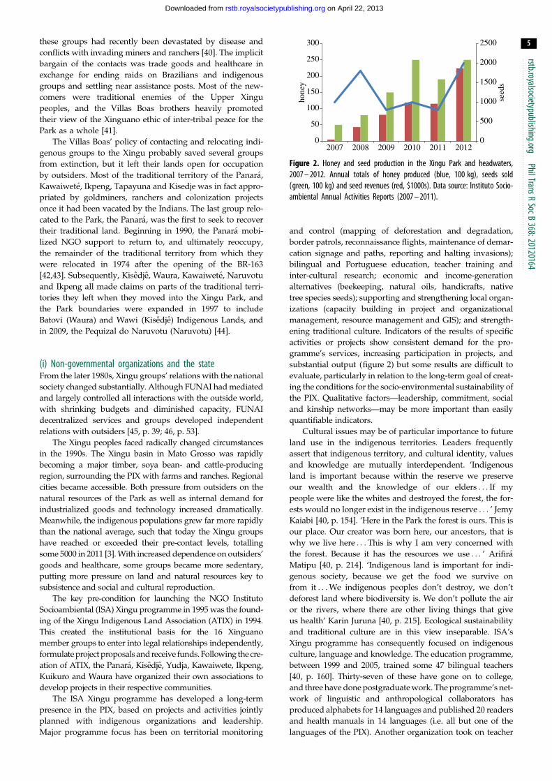
Figure 2. Honey and seed production in the Xingu Park and headwaters,2007 – 2012. Annual totals of honey produced (blue, 100 kg), seeds sold(green, 100 kg) and seed revenues (red, $1000s). Data source: Instituto Socio-ambiental Annual Activities Reports (2007 – 2011).
rstb.royalsocietypublishing.orgPhilTransR
SocB368:20120164
5
on April 22, 2013rstb.royalsocietypublishing.orgDownloaded from
these groups had recently been devastated by disease and
conflicts with invading miners and ranchers [40]. The implicit
bargain of the contacts was trade goods and healthcare in
exchange for ending raids on Brazilians and indigenous
groups and settling near assistance posts. Most of the new-
comers were traditional enemies of the Upper Xingu
peoples, and the Villas Boas brothers heavily promoted
their view of the Xinguano ethic of inter-tribal peace for the
Park as a whole [41].
The Villas Boas’ policy of contacting and relocating indi-
genous groups to the Xingu probably saved several groups
from extinction, but it left their lands open for occupation
by outsiders. Most of the traditional territory of the Panara,
Kawaiwete, Ikpeng, Tapayuna and Kisedje was in fact appro-
priated by goldminers, ranchers and colonization projects
once it had been vacated by the Indians. The last group relo-
cated to the Park, the Panara, was the first to seek to recover
their traditional land. Beginning in 1990, the Panara mobi-
lized NGO support to return to, and ultimately reoccupy,
the remainder of the traditional territory from which they
were relocated in 1974 after the opening of the BR-163
[42,43]. Subsequently, Kisedje, Waura, Kawaiwete, Naruvotu
and Ikpeng all made claims on parts of the traditional terri-
tories they left when they moved into the Xingu Park, and
the Park boundaries were expanded in 1997 to include
Batovi (Waura) and Wawi (Kisedje) Indigenous Lands, and
in 2009, the Pequizal do Naruvotu (Naruvotu) [44].
(i) Non-governmental organizations and the stateFrom the later 1980s, Xingu groups’ relations with the national
society changed substantially. Although FUNAI had mediated
and largely controlled all interactions with the outside world,
with shrinking budgets and diminished capacity, FUNAI
decentralized services and groups developed independent
relations with outsiders [45, p. 39; 46, p. 53].
The Xingu peoples faced radically changed circumstances
in the 1990s. The Xingu basin in Mato Grosso was rapidly
becoming a major timber, soya bean- and cattle-producing
region, surrounding the PIX with farms and ranches. Regional
cities became accessible. Both pressure from outsiders on the
natural resources of the Park as well as internal demand for
industrialized goods and technology increased dramatically.
Meanwhile, the indigenous populations grew far more rapidly
than the national average, such that today the Xingu groups
have reached or exceeded their pre-contact levels, totalling
some 5000 in 2011 [3]. With increased dependence on outsiders’
goods and healthcare, some groups became more sedentary,
putting more pressure on land and natural resources key to
subsistence and social and cultural reproduction.
The key pre-condition for launching the NGO Instituto
Socioambiental (ISA) Xingu programme in 1995 was the found-
ing of the Xingu Indigenous Land Association (ATIX) in 1994.
This created the institutional basis for the 16 Xinguano
member groups to enter into legal relationships independently,
formulate project proposals and receive funds. Following the cre-
ation of ATIX, the Panara, Kisedje, Yudja, Kawaiwete, Ikpeng,
Kuikuro and Waura have organized their own associations to
develop projects in their respective communities.
The ISA Xingu programme has developed a long-term
presence in the PIX, based on projects and activities jointly
planned with indigenous organizations and leadership.
Major programme focus has been on territorial monitoring
and control (mapping of deforestation and degradation,
border patrols, reconnaissance flights, maintenance of demar-
cation signage and paths, reporting and halting invasions);
bilingual and Portuguese education, teacher training and
inter-cultural research; economic and income-generation
alternatives (beekeeping, natural oils, handicrafts, native
tree species seeds); supporting and strengthening local organ-
izations (capacity building in project and organizational
management, resource management and GIS); and strength-
ening traditional culture. Indicators of the results of specific
activities or projects show consistent demand for the pro-
gramme’s services, increasing participation in projects, and
substantial output (figure 2) but some results are difficult to
evaluate, particularly in relation to the long-term goal of creat-
ing the conditions for the socio-environmental sustainability of
the PIX. Qualitative factors—leadership, commitment, social
and kinship networks—may be more important than easily
quantifiable indicators.
Cultural issues may be of particular importance to future
land use in the indigenous territories. Leaders frequently
assert that indigenous territory, and cultural identity, values
and knowledge are mutually interdependent. ‘Indigenous
land is important because within the reserve we preserve
our wealth and the knowledge of our elders . . . If my
people were like the whites and destroyed the forest, the for-
ests would no longer exist in the indigenous reserve . . . ’ Jemy
Kaiabi [40, p. 154]. ‘Here in the Park the forest is ours. This is
our place. Our creator was born here, our ancestors, that is
why we live here . . . This is why I am very concerned with
the forest. Because it has the resources we use . . . ’ Arifira
Matipu [40, p. 214]. ‘Indigenous land is important for indi-
genous society, because we get the food we survive on
from it . . . We indigenous peoples don’t destroy, we don’t
deforest land where biodiversity is. We don’t pollute the air
or the rivers, where there are other living things that give
us health’ Karin Juruna [40, p. 215]. Ecological sustainability
and traditional culture are in this view inseparable. ISA’s
Xingu programme has consequently focused on indigenous
culture, language and knowledge. The education programme,
between 1999 and 2005, trained some 47 bilingual teachers
[40, p. 160]. Thirty-seven of these have gone on to college,
and three have done postgraduate work. The programme’s net-
work of linguistic and anthropological collaborators has
produced alphabets for 14 languages and published 20 readers
and health manuals in 14 languages (i.e. all but one of the
languages of the PIX). Another organization took on teacher

rstb.royalsocietypublishing.orgPhilTransR
SocB368:20120164
6
on April 22, 2013rstb.royalsocietypublishing.orgDownloaded from
training, and trained an additional 50 teachers. Today, there are
50 schools and 120 teachers in the PIX, teaching children to read
and write first in their native languages, then in Portuguese
[40]. The ISA bilingual education project has become effective
public policy in the PIX. The programme’s other publications
(including many joint efforts with ATIX), on agriculture, art,
ritual, myths, music and oral histories evidence enduring con-
cern with recording and preserving traditional knowledge and
culture [47]. We will return to the issue of cultural values and
sustainability in the following text.
(ii) Fire and degraded headwaters: new threatsDegradation of the riparian forests of the upper headwaters of
the rivers that form the Xingu and changing, more destructive,
fire regimes constitute new and serious, threats to the ecologi-
cal integrity of the PIX and the livelihoods of the Xingu
peoples. Xingu peoples traditionally use fires to burn cleared
forest for new gardens, secondary burning in older gardens,
to burn savannahs and keep village environs and pathways
clear, to ward off bees when collecting honey, and for cooking
fires on hunting, fishing and collecting trips in the forest [3,40]
(M. Heckenberger, personal communication, 11 October 2012).
Both older and younger Xinguanos themselves articulate per-
ceived changes clearly.
I am concerned with the change, today I am very concerned withforest fires . . . because the savanna and forest are burning. For-merly, in the 1970s, these changes had not happened. Until1980, everything was fine, we set fire to the savanna and itwent out by itself, since it stopped right at the edge of thesavanna. Starting in 2000, the fires don’t put themselves out any-more. . . . In my village a lot of forest burned. The fire happensbecause of the heat. We are in a new climate. Arifira Matipu[40, p. 214].
Today our customs are changing. This is what my grandfatherwas saying, there didn’t use to be this heat, there were notproblems with water. Ausuki Kalapalo [40, p. 214].
Fire is different now. When I was little, people didn’t burn likenow. The sun didn’t get as hot as it does now. It alwaysburned and went out. Now, people set fire and it gets awayand there’s a big fire. Before it would burn the savanna butdidn’t burn the forest. Now, we say, ‘I think the weather chan-ged.’ Lahussia Juruna [Interview with Lahussia Juruna, May2007, Tuba-tuba village, Xingu Indigenous Park].
We know when it is time to clear gardens when we see a star (thePleiades) that doesn’t always come out, only when its time tomake gardens . . . When the star comes out in the middle of thesky, it’s the time to stop clearing for gardens. . .In the old daysthe forest was much more humid and because of this only thepart cut down caught fire. Today, all the humidity of naturedries up and more places catch fire . . . The star still comes out,but the rain is very different. Last year we planted a communitygarden . . . and it didn’t grow. The sun got very hot, because therains were very late. The earth was very dry. The river is alsochanging a lot. Before, when the water level fell, it was nice.Now there are more beaches in the middle of the river andalong the banks the level doesn’t fall. Sadea Juruna [48].
If the little group of stars (the Pleiades) appears about at sunsetand the murici (Byrsonima crassifolia) flowers, it’s time to makegardens. They clear forest and wait. When its near time for therains to start, there’s another flowering and when it falls therains come. The people get ready to burn. Then they plant.They know that when it rains, it won’t stop, its the rainyseason. We plant corn, sweet potatoes and more. They comeup well. Before, it was like this. I and the older people noticethe change . . . Another thing is when the rains stop. There’s avine that burns and when its flowers fall, its time for the rainsto stop. The fruits are also changing the way they ripen. Someripen in the summer when they used to ripen in September.
We ask ourselves why these changes are happening . . . The fallof the water level in the rivers is also different. Formerly theriver got really small and then the rains would come, now itdoesn’t dry out as much and the rain already falls.’ Ntoni Kisedje[48] (see the electronic supplementary material).
Xingu indigenous groups’ observations are consistent with
both with remote-sensing observations of fire incidence and
recent literature on the effects of climate change and deforesta-
tion on Amazonian ecosystems—forests that were historically
too moist to burn are beginning, particularly in dry years, to
catch fire [49–52].
Given long-term, widespread indigenous use of fire for
landscape and resource management in the Xingu, indigenous
people’s observations of changed fire regimes may themselves
be taken as early signs of climate change.
Traditional agriculturalists in the Xingu also observe
changes in rainfall regimes that disrupt traditional agricultural
cycles. Indigenous groups throughout lowland South America
traditionally have timed their agricultural cycles to the appear-
ance of the Pleiades in the early evening and their movement
across the sky [53, p. 222 et passim]. As Sadea Juruna notes,
the onset of the rains could be predicted by appearance of
the Pleiades in the middle of the sky, but this is no longer a
reliable indicator. Various Xingu leaders make this observation
[48], and also note changes in river flow.
Waura elders in a village meeting to discuss climate
change observed that the water level of the rivers does not
fall, the rains come late and may fail. In 2005, by their
account, the river rose early, before turtle eggs had hatched
and killed the hatchlings (Meeting with traditional leaders
on climate change, Waura village, PIX, 24 April 2011). In gen-
eral, Xingu indigenous people’s observations of changes in
in-stream flows appear consistent with observations and pre-
dictions in the hydrology literature of increased flow in
increasingly deforested catchments [54–56].
Indigenous observations of changing fire, rainfall and river
flow regimes clearly merit more research, both because many
indigenous people are intimately acquainted with the ecosys-
tems they inhabit and are careful observers, and because
much of their resource use and management is based in oral
traditions spanning hundreds of years or more. Using the
rising of the Pleiades as an indicator of the onset of the rainy
season is observed across lowland South America and can
thus be assumed to be a very ancient practice. If, in fact, it
has become or is becoming an unreliable indicator, this—and
other indigenous observations based in traditional agro-bio-
logical knowledge—may also be early signs of climate change.
The ISA, with ATIX, has since 2010 initiated a fire preven-
tion and control project, initially with eight villages in the
PIX, mobilizing FUNAI and IBAMA to participate in training
courses and to draft a fire prevention plan for the region.
While the IBAMA fire prevention programme, Prevfogo,
has plans for protected areas, it lacks an approach to the
problem in indigenous territories. Some years before the
Xinguanos expressed concerns with fires and rainfall, many
were already alarmed by changes in water quality.
(iii) Multi-stakeholder effort to restore degraded headwaters: theXingu headwaters campaign
All of the upper headwaters of the rivers that form the Xingu
lie outside of the PIX, and have since the 1990s increasingly
been deforested for soya bean and cattle ranching. By the
rstb.royalsocietypublishing.orgPhilTransR
SocB368:20120164
7
on April 22, 2013rstb.royalsocietypublishing.orgDownloaded from
late 1990s, Upper Xingu communities were voicing growing
concern with water quality, turbidity, siltation of riverbeds
and fish populations [40]. For cultural reasons, the traditional
Upper Xingu groups prohibit hunting almost all mammals
and thus depend on fish as their source of protein. A sub-
sequent study of water quality identified increased turbidity,
siltation and water temperature as effects of deforestation of
riparian forest in the upper headwaters [57] that if unchecked,
could compromise fish populations.
Discussion among indigenous leaders, country govern-
ments, landowners and NGO led in 2004, to the launch of
the Xingu headwaters campaign—Y’Ikatu Xingu—in order
to promote voluntary efforts to restore degraded headwaters.
The campaign has engaged a wide array of regional organiz-
ations and governments and promoted some restoration of
riparian forest. It also gave rise to the Seed Network, made
up of indigenous and family farmer seed collectors, who col-
lect native tree species seeds for sale to public and private
restoration efforts, as well as developing mechanized direct
planting of seeds, a lower-cost alternative to seedlings.
Income from seed collection has grown substantially, but
the cost of restoration and lack of effective incentives for land-
owners have constrained restoration to a small fraction of the
area degraded [58,59].
The seed network is potentially a scalable form of income
generation for indigenous people and small farmers, given
the large amount of degraded lands that will, in principle,
have to be restored under the new Forest Code. The head-
waters experience suggests that building multi-stakeholder
networks at a river basin, or sub-basin, level, linking ILPA
and surrounding populations may be a necessary and critical
step towards long-term protection and sustainability of
the ILPAs—but also that restoration of degraded lands will
require very significant investment, public or private, to
come to fruition. The wording of law 12.651/12 (the Forest
Code) authorizing payments for ecosystem services, and the
National REDDþ Policy process (see the electronic sup-
plementary material) offer important opportunities to create
performance-based incentives for the large-scale restoration
of degraded lands.
5. Warrior tradition in the frontier economy: theMebengokre (Kayapo)
The approximately 10.5 million ha in five contiguous Kayapo
territories comprises the largest expanse of forest occupied by
a single ethnic group in the Xingu ILPA corridor. Through
the 1980s and 1990s, the Kayapo repeatedly staged highly vis-
ible demonstrations, blocked roads and expelled goldminers
from their territory, in the process of winning official recog-
nition of their land rights. At the same time, nearly all of
the Kayapo chiefs negotiated deals with illegal mahogany
loggers and gold miners [60, pp. 115–122]. With the exhaus-
tion of mahogany and NGO-organized alternative income
projects in the late 1990s, virtually all of the Kayapo have
stopped logging and mining in their territory [61]. However,
with 2500 km of perimeter, in a newer and more lawless fron-
tier region than the Upper Xingu, and limited government
resources, the Kayapo face ongoing challenges.
The attraction of white people’s goods drew indigenous
groups into the PIX. Kayapo strategies to obtain others’
goods worked in the opposite sense in the middle Xingu.
The Kayapo from mid-nineteenth century occupied the
Xingu basin from about 78 S to 98 400 S, and established
the widely dispersed settlements where most Kayapo
groups were contacted in the 1950s and 1960s in consequence
of ongoing internal feuds among subgroups following differ-
ent chiefs [62] and raiding (or at times trading with) regional
Brazilian settlements for trade goods, particularly firearms
and captives. While many subgroups were decimated by epi-
demics, ‘contact’ with the surrounding society reflected
Kayapo strategies to access outsiders’ goods for their own
social and cultural ends at least as much as any externally
driven process [63]. The Kayapo have developed a self-reflex-
ive, strategic sense of the value and symbolic power of their
own culture and its representation in securing recognition of
their territory and defending it from invasions [61] (see §7).
There are now some 9000 Kayapo in about 40 villages [64].
At the highly publicized Kayapo protest against the Belo
Monte dam in Altamira in 1989, some environmentalist visit-
ors were alarmed when they learned of Kayapo logging and
mining. Anthropologist Terry Turner argues that while the
Kayapo readily extract and even deplete forest resources,
they regard the total ecosystem destruction entailed in
clear-cutting as morally and aesthetically repugnant [65].
From this perspective, selective logging or localized gold
mining is not necessarily inconsistent with forest protection.
Selective logging for mahogany in the Kayapo lands, where
they control access, has limited ecological impacts.
In 1992, at the request of Kayapo leaders, NGOs created a
biological research station as an income alternative. A’Ukre vil-
lage declared 10000 ha off limits to hunting and logging, in
exchange for researchers’ payments and training Kayapo assist-
ants, with benefits distributed evenly across the community—
unlike timber and gold payments controlled by chiefs.
The relative success of the research station—and depletion
of mahogany stocks—led leaders of nearly all of the Kayapo
villages to create the Protected Forest Association (AFP) in
2002, to support border control and develop alternatives
across the territories. Western and southern communities
founded the Raoni Institute (IR) in 2001, and the Kabu Institute
(IK) in 2008.
The Kayapo organizations, in collaboration with chiefs
and FUNAI, organize regular border patrols and have been
highly successful in preventing or halting attempted ranching
and gold mining invasions [61], but the recurrent costs of
these activities are far beyond current FUNAI budgets and
depend at present on philanthropy.
In the absence of outside support, the Kayapo, like other
forest communities, face stark choices in the current regional
economy between unsustainable, typically illegal but high-
value activities and low-value non-timber forest products
and handicrafts. AFP and IK have over the past 5 years devel-
oped Brazil nut marketing in seven communities, a venture
that has sold on average about 150 tonnes of Brazil nuts
over the past 3 years and generated some $160 000
annually—at a price well above the government-set mini-
mum [66]. Handicrafts, collection of natural essences and
oils, and a field course on conservation and development
are under development. In addition, NGOs and the
Amazon Fund have granted the Kayapo an $8 million
endowment, which will generate about $400 000 per year,
both for project support and part of the administrative costs
of their three associations. The value of loggers’ and goldmi-
ners’ payments to Kayapo chiefs in the 1980s and 1990s are
rstb.royalsocietypublishing.orgPhilTransR
SocB368:20120164
8
on April 22, 2013rstb.royalsocietypublishing.orgDownloaded from
unknown, but were probably an order of magnitude greater
than project income or more.
Kayapo groups have adopted a series of strategies to access
Western goods and technology—raiding, ‘contact’, logging and
mining, and alternative projects—with considerable success,
while maintaining an independent stance in relation to the sur-
rounding society. The Kayapo emphatically reject the naive but
still widespread assumption that ‘real’ Indians neither have nor
need white people’s goods and technology; cash poverty is not
an option they entertain. Their organizations have prioritized
territorial protection and economic alternatives, but if economic
alternatives cannot be scaled to meet increasing demand, their
market access strategies could change. While the Belo Monte
dam is currently the only proposed hydroelectric project on
the Xingu, the prospect of upstream dams is of great concern,
even as regional power company Eletronorte has begun funding
Kayapo projects. Kayapo and Panara now access conditional
cash transfers (CCT) such as the ‘family grant’ (bolsa familia).
These programmes may have unintended social and health
effects in indigenous groups (see the electronic supplementary
material). Substantial external funds will be needed to maintain
territorial control projects and bring commensurate income
generation through activities that the Kayapo control. The
Kayapo NGOs provide the basis for the institutions needed to
administer them.
6. Closing the gap in the Xingu-protected areascorridor: Anfrızio River, Iriri and middle XinguExtractive Reserves (Resex)
The government’s creation of the Terra do Meio Reserves
Mosaic from 2004 to 2008 completed the 28 million-ha-
Xingu-protected areas corridor, halted rampant illegal occu-
pation of public lands and deforestation, and guaranteed
the land rights of some 215 riverine families [67], many of
whom were previously threatened with imminent expulsion
by land-grabbers. Originally proposed by the Transamazon
social movement [26,67], creating the mosaic and attendant
legal action largely resolved major land tenure issues—in
2006, for example, the Federal Attorney General’s Office
(MPF) won a lawsuit extinguishing claims by one individual
to between 4.7 and 7 million ha [3, p. 32] in the region.
Providing basic healthcare and education in the Extractive
Reserves (Resex)—in principle, the responsibility of the
county—is an ongoing issue. Resex communities are up to a
week away by boat from the county seat and nearest town,
Altamira. NGOs and the reserve residents’ associations, with
some government support, have built 10 schools and three
health posts in the three reserves, as well as equipping the
associations with shortwave radios and boats. The NGOs,
responding to community demand, brokered agreements with
companies to purchase native rubber (abandoned since the
1980s because of low prices) and copaiba (Copaifera spp.) oil
from the reserves at premium prices, and introduced processing
technology for oils extracted from other forest products.
Deforestation in the ILPAs of the Terra do Meio declined
after reserve creation (see the electronic supplementary
material). Deforestation in the Triunfo do Xingu Environmen-
tally Protected Area (APA), where ranchers retain property
rights, began to decline after its creation in 2006. It was probably
also affected by the post-2008 credit freeze imposed the
Environment Ministry and National Monetary Council on
the highest-deforestation municipalities in the Amazon
(http://climatepolicyinitiative.org/riodejaneiro/files/2013/
01/Does-Credit-Affect-Deforestation-Evidence-from-a-Rural-
Credit-Policy-in-the-Brazilian-Amazon-Technical-Paper-English.
pdf accessed 16 February 2013). Because nearly all of the
approximately 8 million ha Terra do Mosaic was terra devoluta,
or unclassified public land subject to widespread land grabs
[25,26], the legal creation of the ILPAs probably accounts for
much of the decline in deforestation, as elsewhere [68,69].
Localized illegal logging has, however, increased in some
areas of the Terra do Meio. Residents of the Anfrızio Resex
reported an invasion in 2010 and while ICMBio seized timber
and equipment, logging continues. Remote-sensing analysis
of the Terra do Meio (for methodology, see the electronic sup-
plementary material) showed an increase in logging roads
in the Anfrızio Resex from 2005 to 2011 (see the electronic sup-
plementary material). A 2005–2011 comparison of endogenous
roads shows a decrease for the ILPAs overall of roughly 3500
km to about 1000 km—substantial, although numerical
values are uncertain. In addition, an analysis of the historically
deforested areas detected by PRODES showed that nearly half
of the Terra do Meio deforestation patches detected from 1997
were regenerating (NDFI . 186) in 2011, suggesting that
land-grabbers had abandoned previous clearings in the newly
created protected areas.
7. Discussion: indigenous lands andprotected areas—effective managementand sustainability
A considerable literature supports the view that ILPAs and
indigenous territories in particular are effective barriers to
frontier expansion and deforestation [69–71]. Data from
the Xingu ILPAs support this conclusion. Deforestation in the
Xingu basin is heavily concentrated outside the ILPAs. Of the
approximately 10 million ha deforested in the basin through
2010, 91 per cent was outside protected areas, 3 per cent was in
indigenous lands, 1.4 per cent in federal protected areas and
4 per cent in state protected areas [3, pp. 49,50] (see the electronic
supplementary material). Fires are also apparently much less fre-
quent inside reserves than outside [70]. A more difficult question
is what this tells us about the prospects and conditions for the
long-term sustainability of these territories.
Reserve histories suggest that the most degraded of the
ILPAs are those in which invasion began before legal recog-
nition or creation of the territory. About 55 per cent of the
deforestation in the indigenous lands in the ILPA corridor is
concentrated in the Cachoeira Seca and Apyterewa lands, in
both of which invasion began before or in the early stages of
demarcation [3, p. 15]. Maraiwatsede, partially within the
Xingu basin but not contiguous with the corridor, was heavily
invaded before the Xavante subgroup, removed from the
area in the late 1960s, returned to the territory in early 1990s.
The area is currently the most deforested indigenous territory
in the Amazon (http://maraiwatsede.org.br/tags/maraiwat-
sede-0 accessed 17 February 2013). The Panara, by contrast,
removed from their territory at around the same time, returned,
called on FUNAI to begin demarcation and removed invaders
before large-scale deforestation began. The most heavily defor-
ested area in the Xingu corridor, the APA Triunfo do Xingu,
rstb.royalsocietypublishing.orgPhilTransR
SocB368:20120164
9
on April 22, 2013rstb.royalsocietypublishing.orgDownloaded from
was proposed as an APA because deforestation and occupation
by the time of the initial survey were too advanced for a more
restrictive type of protected area.
Increasing local participation and production in NGO-led
economic projects (figure 2) demonstrates strong local
demand for income and market access. It is indicative that
only two of the 40 Kayapo villages, Gorotire and Kriny, have
decided not to work with the NGOs and allow gold mining
and logging in their territory. This may suggest that the
majority of the Kayapo expect a greater return from alternative
projects than they could obtain from logging for low value tree
species (Madeira branca) and dwindling superficial gold depos-
its, or that NGO project benefits are more equitably distributed
[61]. It may also be rooted in historical inter-village factional
disputes [62,64]. There is, however, good reason to believe
that more is at issue here, and not only in the Kayapo territories.
Indigenous and traditional communities consistently affirm
that cultural identities and territories depend on one another.
A recent study shows that Iriri Resex of community mem-
bers’ motives for wanting to live in the reserve [72] were not
restricted to material concerns with access to resources or
income, but were also based on a strong sense of place inform-
ing riverine people’s (ribeirinhos) identities. Ribeirinhos value
their productive activities and environment for both economic
and affective reasons; their support for the reserve has more
than just political–economic motivation. Similarly, indigenous
peoples repeatedly assert a fundamental interdependence
between culture and identity and territory [73]. Indigenous
‘traditional knowledge’ of forest ecologies and resources, and
grounding of culture and identity in territory, are based in cul-
turally distinct cosmologies and world views that differ
fundamentally from Western science. While Western science
draws a sharp distinction between a natural world ruled by
material forces and a cultural realm of values, conventions
and concepts, indigenous peoples, Amerindian societies in par-
ticular, include animals, plants and other ‘natural’ phenomena in
the domain of culture and society [74–76]. Amerindian resource
knowledge arises from mutual recognition, active communi-
cation and exchanges amongst people, animals, plants,
geographical features, spirits and the dead conceived as actors
in the same socio-cosmological networks. The full statement of
Ntoni Kisedje to the Cuiaba Seminar on Climate Change and
Agriculture [48], cited in part above on climate change impacts,
illustrates this (see the electronic supplementary material). This
has several implications. First, environmentalists, but who
wish to develop conservation projects with indigenous commu-
nities, but who ignore or fail to understand these differences, risk
serious miscommunications and limited project results [77]. But
also, this encounter of epistemologies creates the possibility for
inter-cultural dialogue and exchange particularly relevant to
the sustainability of Amazon indigenous territories.
Turner argues that the Kayapo’s successes in influencing
national and regional development policy, in particular in
winning control of their territories, was predicated on the trans-
formation of Kayapo social consciousness from the 1960s to the
1980s [78]. At the beginning of this period, the Kayapo regarded
their social organization, ceremonies, arts and traditional econ-
omy simply as ‘the way they had always done things’ [78,
p. 293], or part of the ‘natural’ order. Developing a self-reflexive
view of their own culture as distinct, and as the product of their
actions, allowed the Kayapo to unify politically and mobilize to
contest threats to their territory, conceived as the basis of their
existence as a distinct ethnicity. The Kayapo, in fact, repeatedly
and successfully staged dramatic public events featuring prom-
inent representations of Kayapo culture and warrior ethos,
generating national and international attention to their issues.
The use of video technology to document confrontations
with the surrounding society as well as their traditional culture
became a central part of this process of self-empowerment.
Conceiving, and recording, themselves as a separate culture
allowed the Kayapo to assert the value of their culture, in con-
trast to and parity with the surrounding society, and
consequently to take political action on their own behalf.
This sort of self-reflexive understanding of indigenous
culture and knowledge, and their value in relation to other
cultures and knowledge systems, are necessary conditions
for dialogue between Western science and indigenous know-
ledge on terms of epistemological, if not political–economic,
equality. Indigenous knowledge of itself is typically not suf-
ficient to deal with Western diseases or meet market needs.
But, as indigenous leaders consistently affirm, identity with
their territories is grounded in traditional culture and know-
ledge, and losing this will lead them to behave as white
people always have. Bilingual education, and teacher training
[40], training bi-cultural health monitors, training filmmakers
and producing indigenous videos (video in the villages,
see http://www.videonasaldeias.org.br/2009/ accessed 22
February 2013; Caititu Institute village in action, see http://
www.institutocatitu.org/en/ accessed 22 February 2013)
enable young people in particular, to view their own distinct
cultures and value them, while engaging modern technology
and the surrounding society. Further examples are provided
by more than 40 publications in indigenous languages of
ISA’s Xingu and Upper Rio Negro programmes [44] (http://
www.socioambiental.org/inst/pub/cartilhas_html accessed
21 February 2013). Various experiences of collaborative, inter-
cultural research between scientists and indigenous and
traditional partners, including several in the Xingu [22,73,79,
80] may suggest a particularly productive approach. In short,
sustainability in ILPAs, including the Xingu, cannot be con-
ceived or measured in purely ecological or economic terms.
As leaders such as Ntoni constantly reiterate, it is also a
question of the viability and vitality of cultures.
Clearly, however, the sustainability of ILPAs also depends
on sustainable sources of finance. REDDþ and payment for
ecosystem services, whether from public or private sources,
have often been proposed as options. A rough estimate,
based on modelling of the gradual, bottom-up development
of carbon markets from 2015 to 2030 suggests that the value
of the Xingu ILPAs under a national emissions trading
system might approximate $42 million per year (see the
electronic supplementary material). Recent proposed and
existing legislation and policies could contribute significantly
to maintaining the ILPAs and increasing headwaters restor-
ation (see the electronic supplementary material). There are
also, however, proposals to introduce industrial agriculture
and mining in indigenous lands.
8. ConclusionThe Xingu ILPAs corridor is a highly socio-environmentally
diverse landscape, continuously inhabited over at least the last
millennium, and a critical source of ecosystem services—
biodiversity conservation, carbon sequestration, watershed
protection, maintenance of rainfall regimes—themselves the
rstb.royalsocietypublishing.orgPhilTransR
SocB368:20120164
10
on April 22, 2013rstb.royalsocietypublishing.orgDownloaded from
historical products of, and largely dependent upon, ancient, his-
torical and contemporary socio-culturally highly diverse
populations. Creation of protected natural reserves and legal rec-
ognition of indigenous territories has, so far, halted frontier
expansion and deforestation, although localized illegal logging
continues. NGO work in the ILPAs has been effective in
enabling the PIX, Panara and Kayapo peoples to control the
boundaries of their territories, as well as in supporting the cre-
ation of local institutions—indigenous and extractive reserve
residents’ associations—necessary for community control and
management of the territories. The ISA’s bilingual education
programme in the PIX, started as an NGO initiative, has
become effective public policy and could serve as a template
for other indigenous territories. Economic alternative projects
have clearly generated increasing participation and production,
but are far from meeting community demand for income and
market access. These projects can be scaled up, but with the
possible exception of the Seeds Network, will, at least in the
near term, require continued outside investment and support
to grow, as well as continued capacity building for community
members to manage local enterprises effectively.
Indigenous leaders in the PIX report changes in fire and
rainfall regimes that may be early indicators of climate
change. Because both the use of fire as a management tool,
and timing of the agricultural cycle according to the appear-
ance of the Pleiades are widespread and ancient practices,
Xingu people’s recent reports of changes in forest flammabil-
ity, in-stream water flows and timing of rains are significant.
Michael Heckenberger’s observation that ‘ . . . the unique
and highly constructed landscapes of the Xingu . . . over the
past one thousand years have changed as much because of pol-
itical as ecological factors’ [24, p. 5] applies as much to the
future of the Xingu as to its past. To the political and ecological,
we would add cultural factors. Xingu—and many other—
indigenous leaders clearly and consistently affirm that from
their perspective, territory, cultural identity and traditional
knowledge are mutually interdependent. Self-reflexive under-
standing and valuing of traditional culture and knowledge as
distinct from Western values and science, including dialogue
between Western science and traditional knowledge, are key
conditions for the sustainability of these territories.
Sustainability—ecological, economic, political and socio-
cultural—in the Xingu corridor will also require new govern-
ance structures and processes. Currently, no one speaks for
the Xingu ILPAs in development policy debates. Given
the lack of any legal structure to govern territories of these
dimensions and diversity, and historical antipathy between
indigenous and environmental agencies, the evolution of
new forms of governance for such territories will be from the
bottom up, with the development of networks, coalitions,
forums and associations that can represent the shared concerns,
interests and aspirations of highly diverse populations for the
future of their territories and landscapes.
The authors thank the Gordon and Betty Moore Foundation, theInternational Conservation Fund of Canada, the Rainforest Foun-dation Norway and Fundo Vale for their support for project workin the Xingu. Ruben Lubowski and Jason Funk commented on thepaper, and James Murray helped assemble the figures and manu-script. We also thank three anonymous reviewers and the editor fortheir very thoughtful comments.
References
1. Soares-Filho B et al. 2010 Role of Brazilian Amazonprotected areas in climate change mitigation.Proc. Natl Acad. Sci. USA 107, 10 821 – 10 826.(doi:10.1073/pnas.0913048107)
2. IBGE. 2010 Base Cartografica Contınua, aoMilionesimo – BCIM v. 3.0. Rio de Janeiro, Brazil.
3. Villas-Boas A. 2012 De Olho na Bacia do Xingu. SerieCarto Brasil Socioambeintal, v. 5. Sao Paulo, Brazil:Instituto Socioambiental.
4. INPE. 2010 Projeto Prodes: Monitoramento daFloresta Amazonica por Satelite. See http://www.obt.inpe.br/prodes/ (accessed March 13, 2013).
5. Instituto Socioambiental. 2013 Amazonia bajopresion. Red Amazonica de informacionsocioambiental georrferenciada (RAISG). Sao Paulo,Brazil: Instituto Socioambiental.
6. Sutherland WJ. 2003 Parallel extinction riskand global distribution of languages andspecies. Nature 423, 276 – 279. (doi:10.1038/nature01607)
7. Chapin M. 2004 A challenge to conservationists.World Watch 17, 17 – 31.
8. International Labour Organization. 2013 Conventionno. 169. See http://www.ilo.org/indigenous/Conventions/no169/lang – en/index.htm(accessed 22 February 2013)
9. United Nations. 2008 United Nations declaration onthe rights of indigenous peoples. See http://www.
un.org/esa/socdev/unpfii/documents/DRIPS_en.pdf(accessed 22 February 2013)
10. Mamdani M. 2012 Define and rule: native aspolitical identity. Cambridge, MA: HarvardUniversity Press.
11. Mamdani M. 2012 What is a tribe? Lond. Rev. Books34, 20 – 22.
12. Ribeiro D. 2005 Os Indios e a Civilizacao: aintegracao das populacoes indıgenas no Brasilmoderno. Sao Paulo, Brazil: Companhia das Letras.
13. Lei No. 6.001 de 19 de dezembro. 1973 Dispoesobre o Estatuto do Indio. See http://www.funai.gov.br/quem/legislacao/estatuto_indio.html(accessed 21 February 2013).
14. Ricardo B. 2004 Contemporary native sociodiversity inBrazil and biodiversity in the Amazon. In Biodiversityin the Brazilian Amazon (ed. JPR Capobianco),pp. 192 – 202. Sao Paulo, Brazil: InstitutoSocioambiental and Editora Estacao Liberdade.
15. Hemming J. 2003 Die if you must: Brazilian Indiansin the twentieth century, pp. 323 – 351. London, UK:Macmillan.
16. Ricardo CA. 1981 Povos Indıgenas no Brasil 1981.Sao Paulo, Brazil: Centro Ecumenico deDocumentacao e Informacao.
17. Campos JDQ. 1987 A galeria da crise permanente. InPovos Indıgenas no Brasil – 85/86 (eds AM Oliva,JP Ramalho, R Alves, ZM Dias), pp. 27 – 29.
Sao Paulo, Brazil: Centro Ecumenico deDocumentacao e Informacao.
18. Republica Federatva do Brasil. 1988 Constituicao.Tıtulo VIII, Capıtulo VIII. Dos ındios p. 150.
19. Santilli M. 1991 Os Direitos Indıgenas naConstituicao Brasileira, pp. 11 – 14. Sao Paulo,Brazil: Centro Ecumenico de Documentacao eInformacao.
20. Viveiros de Castro EB. 2006 No Brasil todo mundoe ındio, exceto quem nao e. In Povos Indıgenasno Brasil 2001 – 2005 (eds C Alberto Ricardo,F Ricardo). Sao Paulo, Brazil: InsitutoSocioambiental.
21. Balee W. 1989 The culture of Amazonian forests. InResource management in Amazonia: indigenous andfolk strategies. Advances in economic botany, vol. 7(eds DA Posey, W Balee). Bronx, NY: New YorkBotanical Garden.
22. Heckenberger MJ, Kuikuro A, Kuikuro UT, Russell JC,Schmidt M, Fausto C, Franchetto B. 2003 Amazonia1492: pristine forest or cultural parkland?Science 301, 1710 – 1713. (doi:10.1126/science.1086112)
23. Heckenberger MJ, Russell JC, Fausto C,, Toney JR,Schmidt MJ, Pereira E, Franchetto B, Kuikuro A.2008 Pre-Columbian urbanism, anthropogeniclandscapes and the future of the Amazon. Science321, 1214 – 1217. (doi:10.1126/science.1159769)
rstb.royalsocietypublishing.orgPhilTransR
SocB368:20120164
11
on April 22, 2013rstb.royalsocietypublishing.orgDownloaded from
24. Heckenberger MJ. 2005 The ecology of power:culture, place and personhood in the southernAmazon, A.D. 1000 – 2000. New York, NY:Routledge.
25. Instituto Socioambiental. 2003 Projeto realizacao deestudos preliminares e formulacao de uma propostatecnica para a implantacao de um mosaico deunidades de conervacao no medio Xingu.Encaminhado para secretaria geral da Organizacaodos Estados Americanos. Sao Paulo, Brazil: InstitutoSocioambiental.
26. Schwartzman S, Alencar A, Zarin H, Souza APS.2010 Social movments and large-scale tropicalforest protection on the Amazon frontier:conservation from chaos. J. Environ. Dev. 19, 274.(doi:10.1177/1070496510367627)
27. Heckenberger M. 2000 Epidemias, ındios bravos ebrancos: contato cultural e etnogenese do AltoXingu. In Os Povos do Alto Xingu: historia e cultura(eds B Franchetto, M Heckenberger). Rio de Janeiro,Brazil: Editora UFRJ.
28. Deneven WM. 1992 The pristine myth: thelandscape of the Americas in 1492. Assoc. Am.Geogr. 82, 369 – 385. (doi:10.1111/j.1467-8306.1992.tb01965.x)
29. Deneven WM. 2007 Pre-European human impactson tropical lowland environments. In The physicalgeography of South America (eds TT Veblen,KR Young, AR Orme), pp. 265 – 278. New York, NY:Oxford University Press.
30. Denevan WM. 2004 Semi-intensive pre-Europeancultivation and the origins of anthropogenic darkearths in Amazonia. In Amazonian dark earths:explorations in space and time (eds B Glaser, WIWoods), pp. 135 – 144. Berlin, Germany: Springer.
31. Bush MB, Silman MR, de Toledo MB, Listopad C,Gosling WD, Williams C, de Oliveira PE, Krisel C.2007 Holocene fire and occupation in Amazonia:records from two lake districts. Phil. Trans. R. Soc. B362, 209 – 218. (doi:10.1098/rstb.2006.1980)
32. Nevle RJ, Bird DK. 2008 Effects of syn-pandemic firereduction and reforestation in the tropical Americason atmospheric CO2 during European conquest.Palaeogeogr. Palaeoclimatol. Palaeoecol. 264,25 – 38. (doi:10.1016/j.palaeo.2008.03.008)
33. Dull RA, Nevle RJ, Woods WI, Bird DK, Avnery S,Denevan WM. 2010 The Columbian encounter andthe little ice age: abrupt land use change, fire, andgreenhouse forcing. Assoc. Am. Geogr. 100,755 – 771. (doi:10.1080/00045608.2010.502432)
34. Schaan DP. 2012 Sacred geographies of ancientAmazonia: historical ecology of social complexity,p. 191. Walnut Creek, CA: Left Coast Press.
35. Glaser B, Guggenberger G, Zech W, Ruivo MDL.2003 Soil organic matter stability in Amazoniandark earths. In Amazonian dark earths: origin,properties, management (eds J Lehmann, DC Kern,B Glaser, WI Woods), p. 150. Dordrecht, TheNetherlands: Kluwer Academic.
36. Hecht SB. 2003 Indigenous soil management andthe creation of Amazonian dark earths: implicationsof Kayapo practices. In Amazonian dark earths:origin, properties, management (eds J Lehmann,
DC Kern, B Glaser, WI Woods), pp. 355 – 372.Dordrecht, The Netherlands: Kluwer Academic.
37. Schwartzman S. 1988 The Panara of the XinguNational Park: the transformation of a society. PhDthesis, University of Chicago, Chicago, IL.
38. Franchetto B. 1987 A Ocupacao da Regiao dosFormadores e do Alto Curso do Rio Xingu. Laudoantropolıgco contratado pela Fundacao Nacionaldo Indio.
39. Menzes MLP. 2000 Parque do Xingu: uma historiaterritorial. In Os Povos do Alto Xingu: historia ecultura (eds B Franchetto, M Heckenberger). Rio deJaneiro, Brazil: Editoria UFRJ.
40. Kahn M, Campanili M. 2011 InstitutoSocioambiental. Almanaque Socioambiental: ParqueIndıgena do Xingu 50 anos. Sao Paulo, Brazil:Instituto Socioambiental.
41. Villas Boas O, Villas Boas C, Farrar Straus, Giroux. 1973Xingu: the Indians and their myths. New York, NY:Farrar, Straus and Giroux.
42. Schwartzman S. 2010 Nature and culture in centralBrazil: Panara natural resource concepts and tropicalforest conservation. (special issue on people inparks). J. Sustain. Forestry 29, 302 – 327. (doi:10.1080/10549810903548161)
43. Arnt R, Pinto LF, Pinto R. 1997 Panara ‘A Volta dosIndios Gingantes’. Sao Paulo, Brazil: InstitutoSocioambiental.
44. Rolla A, Ricardo FP. 2009 Instituto Socioambiental.Amazonia Brasileira. Sao Paulo, Brazil: InstitutoSocioambiental.
45. Ricardo CA. 1991 Ecumenico de Documentacao eInformacao. Povos Indıgenas no Brasil 1987 – 1990,p. 34. Sao Paulo, Brazil: Ricardo.
46. Ricardo CA. 1996 Instituto Socioambiental. PovosIndıgenas no Brasil 1991 – 1995. Sao Paulo, Brazil:Instituto Socioambiental.
47. Instituto Socioambiental. 2012 ISA agendasocioambiental 2012. Sao Paulo, Brazil: InstitutoSocioambiental.
48. Sadea J. 2008 Statement of Sadea Juruna,traditional leader of the Yudja people, Seminar onClimate Change and Agriculture, Cuiaba, 9 October2008. See http://www.icv.org.br/site/images/biblioteca/0738890001343413012.pdf (accessed 22February 2013)
49. Vegara W, Scholtz M. 2010 Assessment of the risk ofAmazon dieback. Washington, DC: World Bank.
50. Nepstad DC et al. 1999 Large-scale impoverishmentof Amazonian forests by logging and fire. Nature398, 505 – 508. (doi:10.1038/19066)
51. Silvestrini RA, Soares-Filho BS, Nepstad D, Coe M,Rodrigues H, Assuncao R. 2011 Simulating fireregimes in the Amazon in response to climatechange and deforestation. Ecol. Appl. 21,1573 – 1590. (doi:10.1890/10-0827.1)
52. Morton DC, Le Page Y, DeFries R, Collatz GJ, HurttGC. 2013 Understorey fire frequency and the fate ofburned forests in southern Amazonia. Phil.Trans. R. Soc. B 368, 20120163. (doi:10.1098/rstb.2012.0163)
53. Levi-Strauss C. 1969 The raw and the cooked,pp. 217 – 222. New York, NY: Harper & Row.
54. Coe MT, Costa MH, Soares-Filho BS. 2009 Theinfluence of historical and potential futuredeforestation on the stream flow of the AmazonRiver: land surface processes and atmosphericfeedbacks. J. Hydrol. 369, 165 – 174. (doi:10.1016/j.jhydrol.2009.02.043)
55. Hayhoe SJ, Neill C, Porder S, McHorney R, LefebvreP, Coe MT, Elsenbeer H, Krusche AV. 2011Converstion to soy on the Amazonian agriculturalfrontier increases streamflow without affectingstormflow dynamics. Glob. Change Biol. 17,1821 – 1833. (doi:10.1111/j.1365-2486.2011.02392.x)
56. Sahin V, Hall MJ. 1996 The effects of afforestationand deforestation on water yields. J. Hydrol. 178,293 – 309. (doi:10.1016/0022-1694(95)02825-0)
57. Neu V. 2011 Impactos Antropicos nas Cabeceiras doXingu. In Almanaque Socioambiental: ParqueIndıgena do Xingu 50 anos (eds M Kahn,M Campanili). Sao Paulo, Brazil: InstitutoSocioambiental.
58. Malta Campos Filho E et al. In press. The Xinguseed network and mechanized direct-seeding. InGenetic considerations in ecosystem restoration usingnative tree species. A thematic study for the state ofthe world’s forest genetic resources (eds M Bozzano,R Jalonen, E Thomas, D Boshier, L Gallo, S Cavers,S Bordacs, P Smith, J Loo). Rome, Italy: UnitedNations Food and Agriculture Organization.
59. Durigan G, Guerin N, da Costa JNMN. 2013Ecological restoration of Xingu Basin headwaters:motivations, engagement, challenges andperspectives. Phil. Trans. R. Soc. B 368, 20120165.(doi:10.1098/rstb.2012.0165)
60. Centro Ecumenico de Documentacao e Informacao.1984 Os Kayapo e os Garimpos de Ouro. In PovosIndıgenas no Brasil 1987 – 1990 (eds CA Ricardo,D Gallois, FP Ricardo, V Carelli), pp. 115 – 122. SaoPaulo, Brazil: Centro Ecumenico de Documentacaoe Informacao.
61. Schwartzman S, Zimmerman B. 2005 Conservationalliances with Amerindian peoples of the Amazon.Conserv. Biol. 19, 3. (doi:10.1111/j.1523-1739.2005.00695.x)
62. Verswivjer G. 1992 Club fighters of the Amazon:warfare among the Kaiapo Indians of central Brazil.Gent, The Netherlands: Rijksuniversiteit Gent.
63. Gordon C. 2003 Folhas palidas: a incorporacao Xicrin(Mebengokre) do dinheiro e das mercadorias. PhDthesis, Museu Nacional, Rio de Janeiro, Brazil.
64. Jerozolimski A, Ribeiro MBN, Souza CNI, Turner T.2011 Cisoes recentes e mobilidade dos Kayapo. InPovos Indıgenas no Brasil 2006 – 2010, pp. 444 –450. Sao Paulo, Brazil: Instituto Socioambiental.
65. Turner T. 2000 Indigenous rights, environmentalprotection and the struggle over forest resources inthe Amazon: the case of the Brazilian Kayapo. InEarth, air, fire and water: the humanities and theenvironment (eds J Conway, K Keniston, L Mars),pp. 226 – 261. Amherst, MA: University ofMassachusetts Press.
66. Jerozolimski A, Ribeiro MBN. 2011 Castanha-do-Brasil: Geracao de renda e protecao territorial. In

rstb.royalsocietypublishing.orgPhilTransR
SocB368:201
12
on April 22, 2013rstb.royalsocietypublishing.orgDownloaded from
Povos Indıgenas no Brasil 2006 – 2010, pp. 4451 –454. Sao Paulo, Brazil: Instituto Socioambiental.
67. Campos M, Nepstad D. 2006 Smallholders, theAmazon’s new conservationists. Conserv. Biol. 20,1553 – 1556. (doi:10.1111/j.1523-1739.2006.00546.x)
68. Hayashi S, Souza Jr C, Pereira K. 2009Monitoramento do Desmatamento em AreasProtegidas no Para. O Estado da Amazonia, 11, 8.Belem, Brazil: Imazon.
69. Pffaf AT, Robalino J. 2013 Crossing paths: role ofprotected areas and deforestation in the BrazilianAmazon. Washington, DC: World Bank.
70. Nelson AN, Chomitz KM. 2009 Protected areaeffectiveness in reducing tropical deforestation: aglobal analysis of the impact of protection status.Washington, DC: World Bank.
71. Nepstad D et al. 2006 Inhibition of Amazondeforestation and fire by parks and indigenous
lands. Conserv. Biol. 20, 65 – 73. (doi:10.1111/j.1523-1739.2006.00351.x)
72. Zarin HL. 2010 Making place and identity in theinterstices: ribeirinho landscaps in the Terra doMeio, Para. PhD dissertation, Department ofAnthropology, University of Florida.
73. Cabalzar A. 2010 Manejo do Mundo – Conhecimentos ePraticas dos Povos Indıgenas do Rio Negro. Sao Paulo,Brazil: Instituto Socioambiental/FOIRN.
74. Descola P. 1994 In the society of nature: a nativeecology in Amazonia. Cambridge, UK: CambridgeUniversity Press.
75. Viveiros de Castro E. 1998 Cosmological Deixis andAmerindian perspectivism. J. Royal Anthropol. Inst.4, 469 – 488. (doi:10.2307/3034157)
76. West P. 2005 Translation, value, and space:theorizing and ethnographic and engagedenvironmemntal anthropology. Am. Anthropol. 107,632 – 642. (doi:10.1525/aa.2005.107.4.632)
77. West P. 2007 Conservation is our government now:the politics of ecology in Papua New Guinea, 2ndedn. Durham, NC: Duke University Press.
78. Turner T. 1991 Representing, resisting, rethinking:historical transformation of Kayapo culture. InColonial situations: essays on the contextualizationof ethnographic knowledge (ed. GW Stocking),pp. 285 – 313. Madison, WI: University of WisconsinPress.
79. Zimmerman B, Peres CA, Malcolm JR, Turner T. 2001Conservation and development alliances with theKayapo of south-eastern Amazonia, a tropical forestindigenous people. Environ. Conserv. 28, 10 – 22.(doi:10.1017/S0376892901000029)
80. da Cunha MC, de Almeida MB. 2002Enciclopedia da Floresta. Enciclopedia da Floresta:O Alto Jurua: Praticas e Conhencimentos dasPopulacoes. Sao Paulo, Brazil: Compania dasLetras.
2 016 4