


Idiomas
Páginas
Jurídico

1All Rights Reserved. No part of this document may be reproduced, stored in a retrieval system, or transmitted, in any form or by any means, electronic, mechanical, photocopying, recording or otherwise, without the prior written permission of DEIMOS Imaging S.L. (Photos ESA, DMC, Eumetsat)
Productos y ServiciosProductos y Servicios
Excelencia en teledetecciExcelencia en teledeteccióónn

2All Rights Reserved. No part of this document may be reproduced, stored in a retrieval system, or transmitted, in any form or by any means, electronic, mechanical, photocopying, recording or otherwise, without the prior written permission of DEIMOS Imaging S.L. (Photos ESA, DMC, Eumetsat)
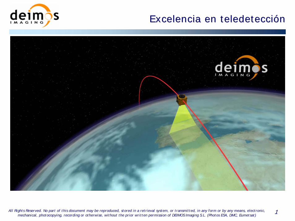
• Sistema y Componentes– Segmento Vuelo
– Segmento Tierra
– Segmento Usuario
• Productos
– Agricultura
– Medio Ambiente
– Forestal
– Otros
DEIMOS Imaging Asegura
Calidad y Fiabilidad
Source: UK-DMC SST Ltd
Source: UK-DMC SST Ltd
ÍÍndicendice
3All Rights Reserved. No part of this document may be reproduced, stored in a retrieval system, or transmitted, in any form or by any means, electronic, mechanical, photocopying, recording or otherwise, without the prior written permission of DEIMOS Imaging S.L. (Photos ESA, DMC, Eumetsat)
Sistema y ComponentesSistema y Componentes
Segmento Usuario(Procesado de Datos y
Aplicaciones)
MSO - 3
Antena 2
Antena 1
Segmento Tierra
• Diseñado para Aplicaciones en:– Agricultura– Medio Ambiente– Forestal– Otras
• Satélite Multiespectral SSTL• Bandas Rojo, Verde e IRC
equivalentes de Landsat• Alta resolución espacial (22m)• Gran amplitud de campo (600 Km)• Alta capacidad de revisita
• Antenas de captura en Boecillo (Valladolid) y Norte de Europa
Segmento Vuelo
4All Rights Reserved. No part of this document may be reproduced, stored in a retrieval system, or transmitted, in any form or by any means, electronic, mechanical, photocopying, recording or otherwise, without the prior written permission of DEIMOS Imaging S.L. (Photos ESA, DMC, Eumetsat)
DEIMOS Imaging Asegura Calidad y FiabilidadDEIMOS Imaging Asegura Calidad y Fiabilidad
• Hereda experiencia y prestigio de DEIMOS Space en el sector aeroespacial
• Hereda experiencia, know-how, datos históricos y
conocimiento científico en Teledetección del LATUV
• Contará con un satélite DMC de alta resolución propio que
asegura el suministro de imagen
• Control de la cadena de producción (integración vertical de las
operaciones)
5All Rights Reserved. No part of this document may be reproduced, stored in a retrieval system, or transmitted, in any form or by any means, electronic, mechanical, photocopying, recording or otherwise, without the prior written permission of DEIMOS Imaging S.L. (Photos ESA, DMC, Eumetsat)
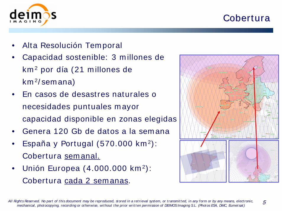
CoberturaCobertura
• Alta Resolución Temporal• Capacidad sostenible: 3 millones de
km2 por día (21 millones de
km2/semana)
• En casos de desastres naturales o
necesidades puntuales mayor
capacidad disponible en zonas elegidas
• Genera 120 Gb de datos a la semana
• España y Portugal (570.000 km2):
Cobertura semanal.
• Unión Europea (4.000.000 km2):
Cobertura cada 2 semanas.

6All Rights Reserved. No part of this document may be reproduced, stored in a retrieval system, or transmitted, in any form or by any means, electronic, mechanical, photocopying, recording or otherwise, without the prior written permission of DEIMOS Imaging S.L. (Photos ESA, DMC, Eumetsat)
Productos Productos -- AgriculturaAgricultura
• Apoyo a la Planificación de Riegos
• Control de Explotación de Acuíferos
• Seguimiento y Evaluación de la Sequía
• Localización y Estimación de Daños por Helada o Granizo
• Informes sobre el Estado Relativo de los Cultivos
(Cuantitativos y Cualitativos): Contenido de Nitrógeno,
Biomasa, Índice de Área Foliar, Anomalías…

7All Rights Reserved. No part of this document may be reproduced, stored in a retrieval system, or transmitted, in any form or by any means, electronic, mechanical, photocopying, recording or otherwise, without the prior written permission of DEIMOS Imaging S.L. (Photos ESA, DMC, Eumetsat)
Agricultura: Informes sobre el Estado de CultivosAgricultura: Informes sobre el Estado de Cultivos
Mapa de Índice de Área Foliar Respecto al Valor Medio de la Parcela
NDVISource: UK-DMC SST Ltd
• Cuantitativo y cualitativo:
– Biomasa y NDVI
– Índice de Nitrógeno
– Área Foliar
• A partir de Datos MODIS y DMC
• Con Referencia Histórica
8All Rights Reserved. No part of this document may be reproduced, stored in a retrieval system, or transmitted, in any form or by any means, electronic, mechanical, photocopying, recording or otherwise, without the prior written permission of DEIMOS Imaging S.L. (Photos ESA, DMC, Eumetsat)
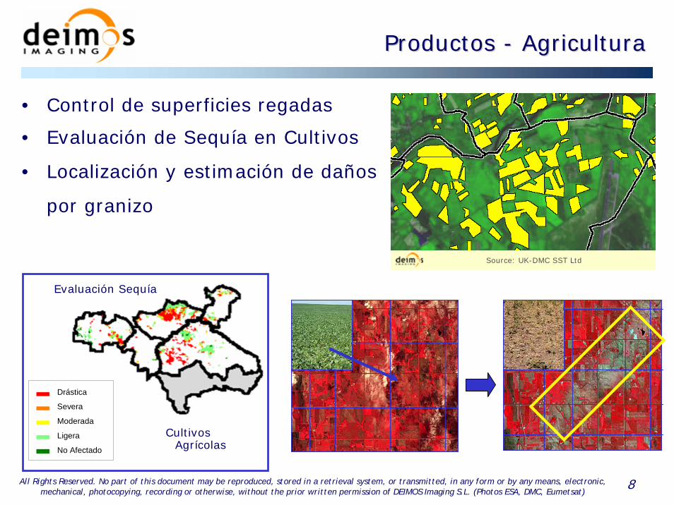
Productos Productos -- AgriculturaAgricultura
Evaluación Sequía
Cultivos Agrícolas
Drástica
Severa
Moderada
Ligera
No Afectado
Drástica
Severa
Moderada
Ligera
No Afectado
Source: UK-DMC SST Ltd
• Control de superficies regadas
• Evaluación de Sequía en Cultivos
• Localización y estimación de daños
por granizo
9All Rights Reserved. No part of this document may be reproduced, stored in a retrieval system, or transmitted, in any form or by any means, electronic, mechanical, photocopying, recording or otherwise, without the prior written permission of DEIMOS Imaging S.L. (Photos ESA, DMC, Eumetsat)
Productos Productos –– Medio AmbienteMedio Ambiente
• Mapa de Usos y Cubiertas del Suelo
• Detección y Seguimiento de Vertidos
• Vigilancia y Seguimiento de Inundaciones
• Planificación Hidrológica de Cuenca y Calidad de Aguas
• Análisis de la Nivosidad de Cuenca
• Cartografía de Áreas Inundables
• Análisis de Ubicaciones para el Aprovechamiento de Energía
Eólica o Solar
• Estimación de la Radiación Eritemática y Espesor de Ozono
10All Rights Reserved. No part of this document may be reproduced, stored in a retrieval system, or transmitted, in any form or by any means, electronic, mechanical, photocopying, recording or otherwise, without the prior written permission of DEIMOS Imaging S.L. (Photos ESA, DMC, Eumetsat)
Productos Productos –– Medio AmbienteMedio Ambiente
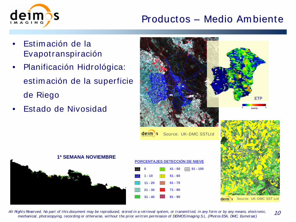
0
1 - 10
11 - 20
21 - 30
31 - 40
41 - 50
51 - 60
61 - 70
71 - 80
81 - 90
91 - 100
PORCENTAJES DETECCIÓN DE NIEVE
• Estimación de la Evapotranspiración
• Planificación Hidrológica:
estimación de la superficie
de Riego
• Estado de Nivosidad
4ª SEMANA ABRIL3ª SEMANA ABRIL2ª SEMANA ABRIL1ª SEMANA ABRIL4ª SEMANA MARZO3ª SEMANA MARZO2ª SEMANA MARZO1ª SEMANA MARZO3ª SEMANA FEBRERO2ª SEMANA FEBRERO1ª SEMANA FEBRERO4ª SEMANA ENERO3ª SEMANA ENERO2ª SEMANA ENERO1ª SEMANA ENERO4ª SEMANA DICIEMBRE3ª SEMANA DICIEMBRE2ª SEMANA DICIEMBRE1ª SEMANA DICIEMBRE4ª SEMANA NOVIEMBRE3ª SEMANA NOVIEMBRE2ª SEMANA NOVIEMBRE1ª SEMANA NOVIEMBRE
Source: UK-DMC SSTLtd
Source: UK-DMC SST Ltd
ETP
11All Rights Reserved. No part of this document may be reproduced, stored in a retrieval system, or transmitted, in any form or by any means, electronic, mechanical, photocopying, recording or otherwise, without the prior written permission of DEIMOS Imaging S.L. (Photos ESA, DMC, Eumetsat)
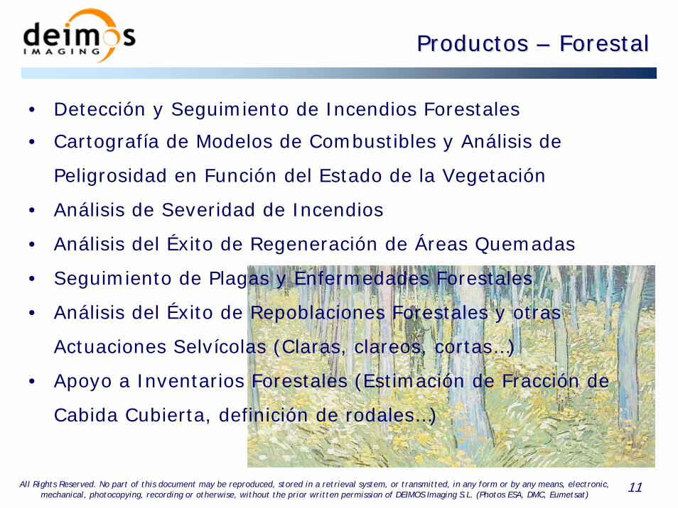
Productos Productos –– ForestalForestal
• Detección y Seguimiento de Incendios Forestales
• Cartografía de Modelos de Combustibles y Análisis de
Peligrosidad en Función del Estado de la Vegetación
• Análisis de Severidad de Incendios
• Análisis del Éxito de Regeneración de Áreas Quemadas
• Seguimiento de Plagas y Enfermedades Forestales
• Análisis del Éxito de Repoblaciones Forestales y otras
Actuaciones Selvícolas (Claras, clareos, cortas…)
• Apoyo a Inventarios Forestales (Estimación de Fracción de
Cabida Cubierta, definición de rodales…)

12All Rights Reserved. No part of this document may be reproduced, stored in a retrieval system, or transmitted, in any form or by any means, electronic, mechanical, photocopying, recording or otherwise, without the prior written permission of DEIMOS Imaging S.L. (Photos ESA, DMC, Eumetsat)
Zonas de Severidad Alta
Productos Productos –– Incendios ForestalesIncendios Forestales
Cartografía de Incendios Forestales
Detección y Seguimiento MSG / MODIS
Dificultades de Regeneración
Mapa de Peligrosidad según el Estado de la Vegetación
Datos MODIS / DMC
Cartografía de Áreas Quemadas
Source: UK-DMC SSTLtd

13All Rights Reserved. No part of this document may be reproduced, stored in a retrieval system, or transmitted, in any form or by any means, electronic, mechanical, photocopying, recording or otherwise, without the prior written permission of DEIMOS Imaging S.L. (Photos ESA, DMC, Eumetsat)
Productos Productos –– ForestalForestal
• Informes del Estado de la vegetación (Análisis espacial y temporal):
– Mapa (visual)
– Análisis Estadístico
• Variables:
– Vectorial - Imagen
– ETP Real
– % Combustible Vivo
– Índices de Vegetación
– Índice de Peligrosidad
– Otros: LAI, Biomasa, etc.
14All Rights Reserved. No part of this document may be reproduced, stored in a retrieval system, or transmitted, in any form or by any means, electronic, mechanical, photocopying, recording or otherwise, without the prior written permission of DEIMOS Imaging S.L. (Photos ESA, DMC, Eumetsat)
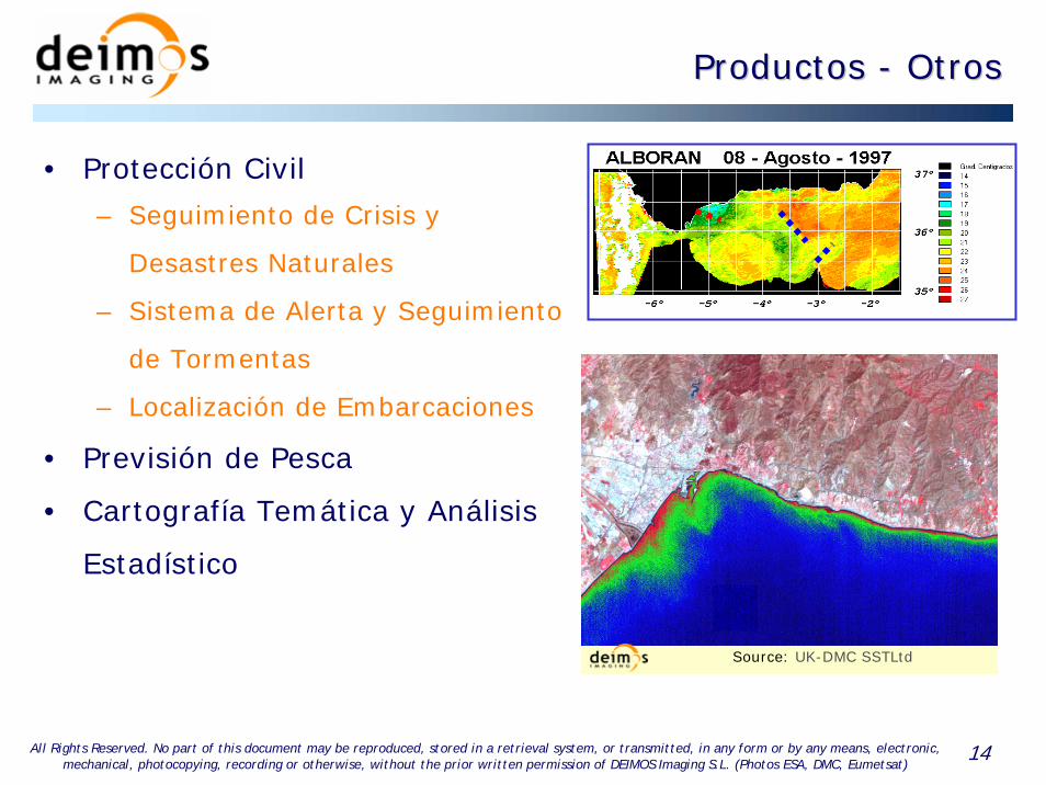
Productos Productos -- OtrosOtros
• Protección Civil
– Seguimiento de Crisis y
Desastres Naturales
– Sistema de Alerta y Seguimiento
de Tormentas
– Localización de Embarcaciones
• Previsión de Pesca
• Cartografía Temática y Análisis
Estadístico
Source: UK-DMC SSTLtd
15All Rights Reserved. No part of this document may be reproduced, stored in a retrieval system, or transmitted, in any form or by any means, electronic, mechanical, photocopying, recording or otherwise, without the prior written permission of DEIMOS Imaging S.L. (Photos ESA, DMC, Eumetsat)
DEIMOS Imaging:DEIMOS Imaging:
Su interlocutor de referencia para Su interlocutor de referencia para la Observacila Observacióón de la Tierran de la Tierra

1All Rights Reserved. No part of this document may be reproduced, stored in a retrieval system, or transmitted, in any form or by any means, electronic, mechanical, photocopying, recording or otherwise, without the prior written permission of DEIMOS Space S.L. (Photos ESA, Eumetsat)
• OBJETIVO: determinar las cantidades de CO2 liberadas a
la atmósfera por los grandes incendios forestales.
• PARA informar a las administraciones públicas con vistas
al cumplimiento de los Tratados Internacionales, (Kyoto),
elaborar estrategias de reforestación, apoyar la solicitud
de ayudas etc.
Futuros desarrollos: Emisiones de CO2Futuros desarrollos: Emisiones de CO2
• PROYECTO CAT-1 APROBADO POR LA ESA

2All Rights Reserved. No part of this document may be reproduced, stored in a retrieval system, or transmitted, in any form or by any means, electronic, mechanical, photocopying, recording or otherwise, without the prior written permission of DEIMOS Space S.L. (Photos ESA, Eumetsat)
DATOS DE ENTRADA:
• Área quemada
• Tipo de combustible
• Severidad
Futuros desarrollos: Emisiones de CO2Futuros desarrollos: Emisiones de CO2
EMISIONES A LA ATMÓSFERA?
SENSORES A BORDO DEL SATELITE EUROPEO ENVISAT
• SCHIAMACHY: CONCENTRACIONES DE O3, O4, N2O, NO2, CO, CO2, H2O, CH4,
• GOMOS: PERFILES VERTICALES DE O3, NO2, NO3, O2, H2O…
• MIPAS: PERFILES DE 20 GASES TRAZA, INCLUYENDO CO
3All Rights Reserved. No part of this document may be reproduced, stored in a retrieval system, or transmitted, in any form or by any means, electronic, mechanical, photocopying, recording or otherwise, without the prior written permission of DEIMOS Space S.L. (Photos ESA, Eumetsat)
• OBJETIVO: utilizar las imágenes radar como apoyo a las
imágenes DMI
Futuros desarrollos: RadarFuturos desarrollos: Radar
• PARA
• Mejorar las clasificaciones de usos del suelo llegando a
determinar el tipo de cultivo y su estado de desarrollo.
• Mejorar las previsiones de cosechas
• Mejorar el conocimiento de los bosques
• Localizar áreas inundadas
• ….

4All Rights Reserved. No part of this document may be reproduced, stored in a retrieval system, or transmitted, in any form or by any means, electronic, mechanical, photocopying, recording or otherwise, without the prior written permission of DEIMOS Space S.L. (Photos ESA, Eumetsat)
Futuros desarrollos: Cambio climFuturos desarrollos: Cambio climááticotico
• Intensidad del eco (backscatter)• Tiempo de ida y vuelta del eco• Tiempo de “rebote”• Onda emitida: vertical u horizontal• ….
Al llevar su propia fuente de “iluminación”, funciona de día y de noche, y las nubes no le afectan, aunque solo mide un tipo de “luz”
blanco
eco
pulso
alcance
5All Rights Reserved. No part of this document may be reproduced, stored in a retrieval system, or transmitted, in any form or by any means, electronic, mechanical, photocopying, recording or otherwise, without the prior written permission of DEIMOS Space S.L. (Photos ESA, Eumetsat)
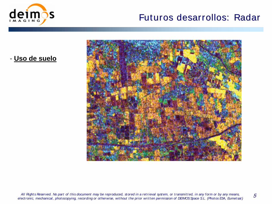
- Uso de suelo
Futuros desarrollos: RadarFuturos desarrollos: Radar

6All Rights Reserved. No part of this document may be reproduced, stored in a retrieval system, or transmitted, in any form or by any means, electronic, mechanical, photocopying, recording or otherwise, without the prior written permission of DEIMOS Space S.L. (Photos ESA, Eumetsat)
- Uso de suelo
- Campos de arroz
Futuros desarrollos: RadarFuturos desarrollos: Radar
7All Rights Reserved. No part of this document may be reproduced, stored in a retrieval system, or transmitted, in any form or by any means, electronic, mechanical, photocopying, recording or otherwise, without the prior written permission of DEIMOS Space S.L. (Photos ESA, Eumetsat)
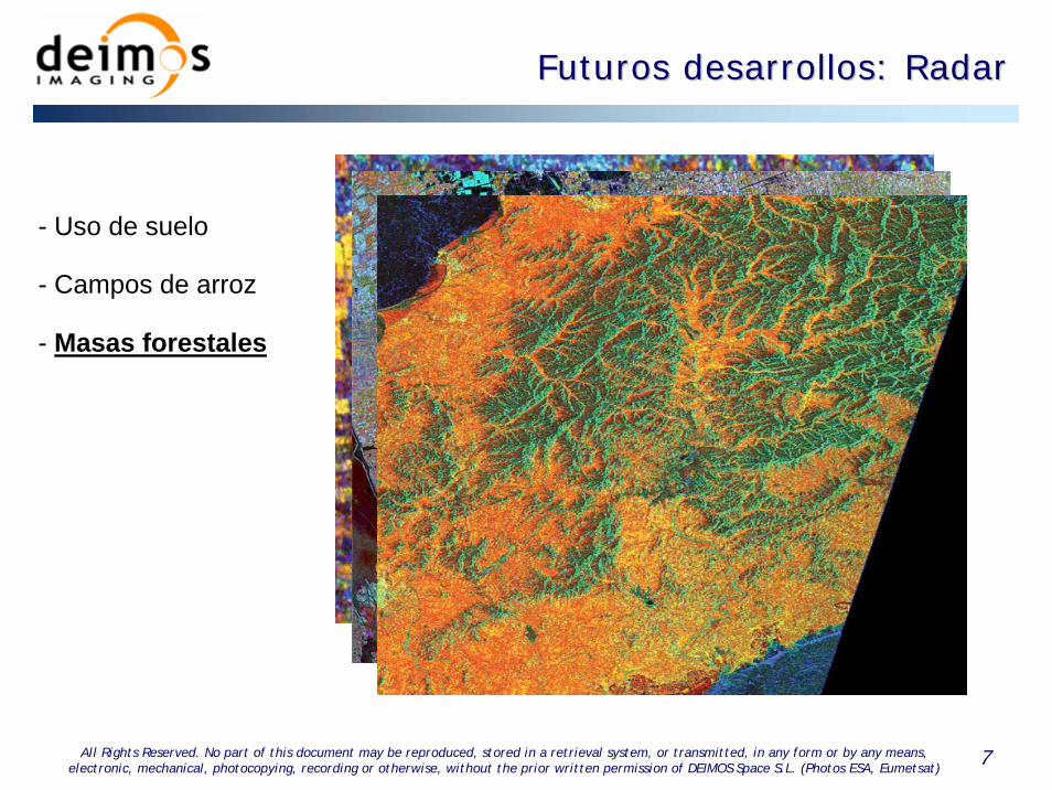
- Uso de suelo
- Campos de arroz
- Masas forestales
Futuros desarrollos: RadarFuturos desarrollos: Radar
8All Rights Reserved. No part of this document may be reproduced, stored in a retrieval system, or transmitted, in any form or by any means, electronic, mechanical, photocopying, recording or otherwise, without the prior written permission of DEIMOS Space S.L. (Photos ESA, Eumetsat)
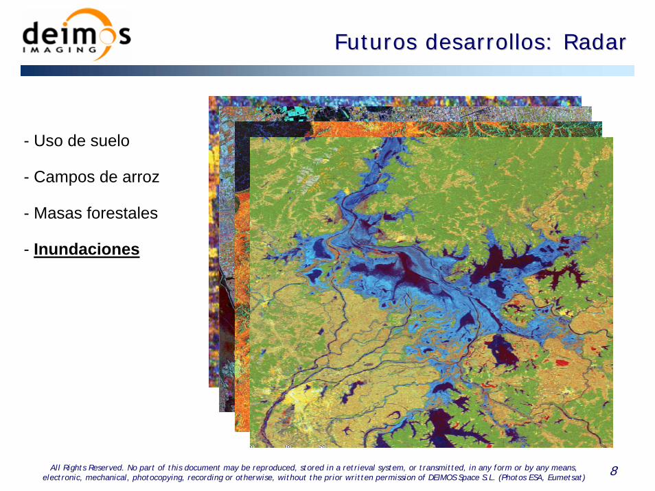
- Uso de suelo
- Campos de arroz
- Masas forestales
- Inundaciones
Futuros desarrollos: RadarFuturos desarrollos: Radar
9All Rights Reserved. No part of this document may be reproduced, stored in a retrieval system, or transmitted, in any form or by any means, electronic, mechanical, photocopying, recording or otherwise, without the prior written permission of DEIMOS Space S.L. (Photos ESA, Eumetsat)
Futuros desarrollos: Cambio climFuturos desarrollos: Cambio climááticotico
• OBJETIVO: detectar los cambios climáticos en el entorno
de la Península Ibérica mediante el análisis temporal de la
presencia de nubes y de las temperaturas del mar
• PARA detectar los cambios que se pudieran producir e
informar a las administraciones públicas, cofradías de
pescadores, empresas relacionadas con las energías
renovables, empresas aeronáuticas, agricultores..
• MEDIANTE las series de imágenes NOAA, METEOSAT y
MSG de que dispone el LATUV (casi 20 años)
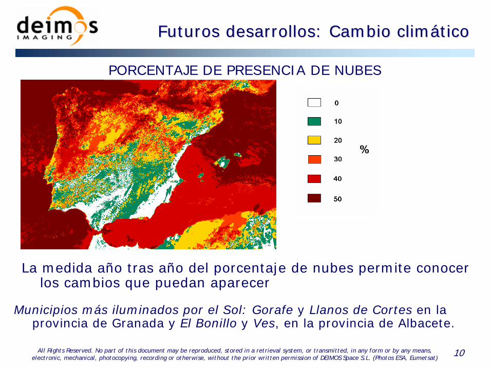
10All Rights Reserved. No part of this document may be reproduced, stored in a retrieval system, or transmitted, in any form or by any means, electronic, mechanical, photocopying, recording or otherwise, without the prior written permission of DEIMOS Space S.L. (Photos ESA, Eumetsat)
Futuros desarrollos: Cambio climFuturos desarrollos: Cambio climááticotico
PORCENTAJE DE PRESENCIA DE NUBES
Municipios más iluminados por el Sol: Gorafe y Llanos de Cortes en la provincia de Granada y El Bonillo y Ves, en la provincia de Albacete.
La medida año tras año del porcentaje de nubes permite conocer los cambios que puedan aparecer
11All Rights Reserved. No part of this document may be reproduced, stored in a retrieval system, or transmitted, in any form or by any means, electronic, mechanical, photocopying, recording or otherwise, without the prior written permission of DEIMOS Space S.L. (Photos ESA, Eumetsat)
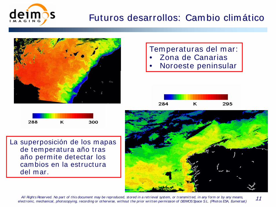
Futuros desarrollos: Cambio climFuturos desarrollos: Cambio climááticotico
Temperaturas del mar:• Zona de Canarias• Noroeste peninsular
La superposición de los mapas de temperatura año tras año permite detectar los cambios en la estructura del mar.
Top Related